 Live Music Archive
 Librivox Free Audio
 Metropolitan Museum
 Cleveland Museum of Art
 Internet Arcade
 Console Living Room
 Books to Borrow
 Open Library
 TV News
 Understanding 9/11
tv Today NBC October 29, 2012 7:00am-11:00am EDT
7:00 am

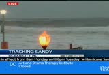
good morning. breaking news. hurricane sandy lashing the east coast this morning from the carolinas into new england. the massive and dangerous system expected to cause life-threatening flooding, power outages and billions of dollars in damage. major cities like washington, d.c., philadelphiand new york, all brought to a halt, and things are about to get much worse today, monday, october 29th, 2012. from nbc news, this is a special edition of "today," hurricane sandy, with matt lauer and savannah guthrie live from studio 1a in rockefeller plaza.
7:01 am

and good morning. welcome to "today" on a monday morning. i'm matt lauer. >> good morning, everyone. i'm savannah guthrie, and it is an anxious morning for folks up and down the east coast. hurricane sandy strengthened over the night. >> want to give you the information we know right now. sandy is a category 1 hurricane with wind speeds of 85 miles per hour. it's located about 285 miles east of cape hatteras, north carolina. emergency officials in new york city and washington, d.c. had taking unprecedented actions to deal with this storm. >> that's righ the mass transit systems shut down, schools cancelled. the stock markets are also closed. the first weather-related closure in 27 years, and just take a look at this nasa image from space. this is one massive hurricane. 800 miles wide which means its impact is going to be felt across a massive region for a very long time. >> you forgot to mention one precaution. starbucks in new york and long island closed this morning.
7:02 am

don't hear that very often. weather officials are calling this mind-boggling. sandy is on a collision course with two other weather systems that are only going to make it more dangerous. in just a couple of hours, those systems will cause sand toe make a left turn and head directly towards the east coast. if that's not enough, there's a full moon tonight which means higher than usual tides. combine that with the expected storm surge, and this is literally a perfect storm, and it could be of historic proportions. >> and add to that the backdrop, of course, a presidential election just eight days away. president obama, governor romney forced to cancel some events and reschedule others. we just got word that the president has cancelled a planned event in florida this morning in order to get back to washington. they were worried air force one may not be able to land in deteriorating conditions. >> we've got correspondents all up and down the east coast. let's start with al roker in point pleasant beach, new jersey. al, what can you tell us? >> reporter: well, i can tell
7:03 am
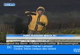
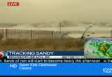
you, matt, that these dunes that i'm on were built for a storm in 1992 that had washed into the town and caused massive damage. these dunes are in damage of breaching. high tide is starting to come up over the dunes. this is a massive storm, as you mentioned, and it will get more intense. it's now over the gulf stream that's running parallel to the east coast. that is extremely warm water. we've seen pressure drops. the pressure is now down to 941 millibars, and it may strengthen even more. we expect more strengthening. take a look at a path of, first of all, sandy right now is 385 miles south southeast of new york city. 85-mile-per-hour winds. it's moving to the north at 15 miles per hour. eventually, as we look at the path, in the next few hours the jet stream that is dipping down to the south is going to force this to the left. this is unprecedented.
7:04 am
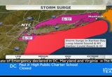
most of the meteorologists i've spoken with and hurricane experts say they have,has not happened, and then it makes landfall sometime late tonight and early tomorrow morning and then meanders its way into interior sections of the northeast. here are the effects we're looking for. first of all, the storm surge. again, what you see behind me, this is indicative of what we're going to see. we're going to see a storm surge as you get from ocean city, maryland, through long island, about 4 to 8 feet, but on the other side of long island and connecticut is long island sound, because of the fetch of the winds, it will pile up the water even more. we're talking storm surges of up to 11 feet, and as you mentioned earlier because of an astronomical high tide because of a full moon it's going to be even worse. the wind is also going to be a big problem. predicted wind gusts of 50, 60 miles per hour stretching from washington, d.c. a the way up to boston later today. those winds will take down trees which in turn are completely still, a lot of placed laden
7:05 am
with foliage. those are l take down power lines. we're expecting power outages, massive power outages from boston, back to buffalo and down to washington, d.c. the rain is going to be a big factor as well. we're talking about especially south of new york city, upwards of a foot or more of rain, but as you get to the north of that area, 7 to 12 inches of rain generally. as if that isn't enough, because this system is pulling in cold air from canada, we have blizzard warnings in effect for parts of west virginia and into the blue ridge mountains of virginia. we're looking at up to one to two feet of snow in some of the upper elevations. this, and we have high wind watches and warnings all across the great lakes with waves of 25 feet on the great lakes, so what we're talking about is a massive system that's going to affect the eastern third of the country. savannah? >> all right, al. thanks. we'll check back in with you. nbc's lester shoelt aboholt is
7:06 am
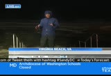
south in virginia beach, virginia where power outages are already being reported. lester, good morning to you. >> reporter: savannah, good morning. fortunately we have power right here along the boardwalk but there's virtually no beach left here. the waves and surges have been powering up here and lapping at the edge of the boardwalk. the northern edge of the storm is almost parallel with us, yet all night we've felt tropical storm gusts of wind. people are hunkered down from here all the way to new england knowing that the worst is yet to come. barrelling towards the east coast, hurricane sandy has nearly 60 million people on severe storm watch this morning. >> kind of scary what's going on here, but hopefully it's going to miss us, and it won't get us. >> reporter: the megastorm stretches more than 800 miles wide, from maine to north carolina. >> this is a serious and big storm, and my first message is
7:07 am

to all people across the eastern seaboard, mid-atlantic, going north, that you need to take this very serisly. >> reporter: police are going door to door in coastal towns such as point pleasant beach, new jersey where storm surge is e greatest concern. more than 1 million people have been given a mandatory evacuation. >> we have four kids so it's sort of the sensible thing. >> reporter: including 375,000 in new york city where the entire transit system has been brought to a halt. no trains, buses or subways until further notice. >> we don't want to encourage people being up and about. >> reporter: transportation nationwide has also been affected with an estimated 6,800 flights grounded so far. frankenstorm, as it has been nicknamed, is expected to bring widespread heavy rainfall of up to 10 inches, couples with destructive wind gusts of 75 miles per hour and in some areas
7:08 am

blizzard snowstorms. the damage, officials estimate, could be in the billions. today, those looking for supplies may find empty shelves after this weekend's mad ru. >> i've already done the grocery shopping, got the flashlight, you know, have the candles, so i just needed to go out and get some ice. >> reporter: while utility crews coming from as far away as illinois are doing their best to control potential power outages. >> last night the power went out for about five seconds which my heart stopped. >> reporter: for now the east coast is just awaiting the eye of the storm. >> hope for the best and expect the worst. >> reporter: there have been no mandatory evacuations at least here in virginia beach, but these are largely tourist areas up and down here. hotels and people have left on their own. this is the boardwalk, and we have seen the water. in fact, right behind me you see it's already surging up to the edge, and in some cases it has come across. people have left.
7:09 am

power is still on in this area. not far from here in norfolk we're told they have seen some flooding. during the night we've seen plenty of localized flooding. rads a roads and streets were already impassable. folks have already left and those left are just waiting to see how bad sandy is going to get. >> thanks, lester. here in new york city mayor bloomberg has evacuated the low-lying areas of manhattan island. more on that in a couple of minutes. to our east in connecticut they are braced for possible historic flooding. as you saw a moment ago, a storm surge of 6 to 11 feet along some parts of the connecticut coastline. nbc's katy tur is in mystic. good morning to you. >> reporter: good morning, matt. that's certainly the big concern. we were out here last night, and the wind wasn't so steady. there were wind gusts. the winds have gotten steadier as the morning has gone on. stronger gusts coming here and there. but the big concern isn't necessarily the rain.
7:10 am

it hasn't started raining here. there won't be a lot of rain up here. the rain will be down to the south. here what they are really concerned about is the storm surge. this is the long island sound. it's already come up about 10 feet since we get here about an hour and a half ago this morning. it's expected to come up a lot farther. it will come up totally on this shore and be significantly higher on the coastal areas. that is the major concern here, the flooding. the governor in a press conference yesterday said that he thinks that this is going to be the worst threat to human life that they have seen in this state in years. that sounds very dramatic, but it isn't so when you think about what irene did to connecticut last year. irene, many people in new york and new jersey rolled their eyes at it and said it wasn't a very big deal. here in connecticut it was a very big deal. here in fairfield there were houses with not just broken windows, houses knocked off foundation and thrown into the water. they expect this to be even worse, the storm surge to be even worse here than it was
7:11 am

during irene. so that's the major concern. there's the mandatory evacuations up and down the connecticut coast. the good news is that most people are heeding those evacuation orders. the other big concern is power outages. all the wind they are expecting to get up here, because the wind is going to be very strong up on the northern edge of this storm. the wind will cause a lot of power outages along with that flooding. they expect -- connecticut light and power expect as many as 600,000 people to be without power here in connecticut for days on end. during irene they were without power for days on end as well so everybody in connecticut is expecting the worst and heeding the orders and just trying to prepare for t.matt? >> all right. katy tur in mystic, connecticut. thanks. connecticut's governor is here with us this morning. >> good to be here, matt. >> you said this could be the biggest threat to face people in
7:12 am

years. >> the tides will affect western long island so that portion from new haven down to the new york border could experience tides this afternoon at about what the perfect storm was. tonight's tide during the nighttime hours could be twice that, and that's our biggest worry. if that happens, it really is catastrophic. the amount of damage and loss of property is going to be extreme. we've been talking about it for days. we've prepared. we have people in the right places. we have equipment in the right places, but really we're waiting to see what mother nature throws at us, but let's be very clear. this storm is staying on script, and that script brings us to the worst result we could possibly have imagined. >> and as a resululult of that, mandatory evacuations and suggested evacuations, how much people in your state do you think have been dispolice e ed
7:13 am

the moment. >> this is a category 4, the highest category emergency that we would consider along the shore. 360,000 people have been urged to leave their homes. that's the number that we're talking about. so put it this way, that's about one-tenth of our entire population, but let's be very clear. you're talking about new haven. you're talking about bridgeport. you're talking about stamford, three of our largest and most important cities with neighborhoods spread throughout every one of the towns that we're talking about. 30 towns have ordered evacuations. it's an extraordinary effort that's under way, and it -- it's different than anything we've ever done. people in connecticut are used to a hurricane being a 6 to 12-hour event. this is a 36-hour event affecting at least four high tides. the first one was last night, not bad, but we needed to get people understanding that each one will get progressively worse. this afternoon's which will be bad, and tonight's which could be catastrophic, that's our big worry. that's why we've urged people to leave as soon as possible.
7:14 am

>> right. >> yesterday and today, if they are there. tonight could just be the worst. >> a house keeping note. your state's only nuclear power plant, the millstone plant up in waterford, connecticut, any plans to shut that down? >> as of last night it had been taken down about 75% of capacity. they will make decisions later today. it's not going to be affected by wind, and it's not going to be affected by tides. it's built pretty high. what they are worried about stuff in the water. >> right. >> so if houses get swept in or other things get swept in, that could threaten. if that happens they will take it down. >> as katy mentioned, we saw massive power outages in the state of connecticut from irene. do you have crews standing by and for people who do lose power over the next 48 hours or so, governor, how long do you think they will be without power? >> if it's in response to flooding, they are going to be out for a long period of time. if we lose the nine substations
7:15 am

that are in tidal affected areas potentially, then this is going to be a long-term event. if we can avoid those being overcome by waves or water, then recovery will be more rapid. so really we're talking about days one way or the other. we could be talking about weeks. >> connecticut's governor dannell malloy. know you're busy this morning. thank you for taking the time to talking with us. appreciate it. >> thank you. >> 7:15. here's savannah. matt, thanks. craig fugate is the fema administrator. mr. fugate, good morning to you. >> good morning. >> i'll start with the simple question. are you ready? >> we've been getting red for the last couple of days. the biggest question with sandy is where and how much damage are we going to see? >> you said when talking to your employees think big. what is your most pressing concern right now? >> well, the most immediate thing is that people have evacuated or are evacuating from
7:16 am

storm surge, but we're also looking at impacts well inland, and generally with hurricanes you tend to focus on the center. this has got a lot of impacts far away. i mean, i have not been around long enough to see a hurricane forecast with a snow advisory in it. >> let's go back to evacuations for a minute. do you feel that people in fact are heeding the warnings and getting out of the danger areas? >> well, i don't know specifically. i hope so, but i've seen the governors and the local officials have gotten out early. they have been doing a good job of messaging. it's really people need to act, and, again, they put up the information. they have given people direction. hopefully people have acted and have gone somewhere safe for the storm. >> you mentioned the magnitude of this storm. can you give us a severance what's been mobilized to deal with some of the impact? >> well, we've got teams basically all the way from down in north carolina where it was earlier impacted in the outer banks and all the way to maine. we have teams in states as far inland as west virginia.
7:17 am
we've been moving generators and basic supplies that we would need after the storm, so it's a large response area, but we also have a lot of good teams with the states and their folks working together getting ready. >> power outages are expected to be one of the big impacts of this storm. is there any way to prevent a power outage, to kind of ward it off, or do you just have to be prepared to deal with the aftermath? >> you need to be prepared. again, we're not expecting the winds themselves inland to be that, you know, damaging, the homes and structures, but we do think trees are going to get impacted. limbs coming down will probably be the biggest problem knocking down the power grid. >> you told your staff on sunday to prepare for what the ifs, to not be complacent. what are the scenarios you're most worried about at this point? >> well, it's kind of going to be as the storm comes ashore. first will be the coastal impacts and then the wind nothinging out power, and then heavy rain, where we may get flash flooding, but in some
7:18 am

cases we may not have river flooding for several days so i don't want people to think it's not that bad when it comes ashore. if you remember with hurricane irene, some of the worst impacts were well inland, like in the state of vermont >> i know it's hard to ask at this point, but do you have any estimate of how much damage from a monetary standpoint this might cause? i mean, are we talking billions? >> too early to say, and, again, our forecast is on life safety. we're prepared to support recovery. we can get the dollar figures after the storm, but we want people to be safe, so we're talking about dollar figures, not loss of life. >> fema administrator craig fugate, a busy morning for you. thanks for being with us. >> thank you. >> matt? >> savannah, we've heard the term perfect storm used in the past and perhaps even too often but sandy really could fit the bill. it's all because of a rare convergence of events that will make the next couple of days unlike any the east coast has ever seen. windows have been boarded, store shelves cleared and residents
7:19 am
evacuated. >> if you refuse to evacuate, you're not only putting yourself at risk but also the first responders who will have to assist you. >> scenes we normally see on the gulf coast instead brought to the northeast by an unusual and potentially devastating mix of ingredients, first hurricane sandy. >> the rush to prepare for sandy is on. >> second, her path. while storms moving up the coast typically drift out to sea, the jet stream is forcing sandy into an almost unheard of left turn. >> we've never seen this. this is unprecedented for a hurricane to take this kind of track. >> and that rare turn points sandy not only towards 60 million people but yet another storm. >> a northern storm combining with a hurricane to be a super storm. it's a hurricane in the middle and a nor'easter outside it. >> frigid air from the north could bring up to two feet of snow, from kentucky, to virginia and north carolina. >> the combination of this
7:20 am
wintertime jet stream coming in and this tropical air coming up is to make more rain, more snow and a bigger storm with more energy in it. >> yet another unlucky piece of the puzzle, a full moon bringing peak tides and making flooding all the more likely. >> flooding is very real and serious concern for many families. i know that for those of you who have lived through this before, my words offer little comfort. >> and one final factor. sandy's sluggish pace, crawling as slow as 15 miles per hour, meaning that the damage, danger and misery won't be going away any time soon. that's some image, the satellite image. by the way, throughout the morning we'll show you storm pictures that you share with us. if you've got a great storm photo tweet it to us using the #sandytoday. >> a lot of anxiety this morning as we await impact of the storm. a lot of people have questions about weather events. tweet or e-mail them to us as
7:21 am
well. we'll try to answer some of those questions a bit later on. for now though we want to go back to al who is in point pleasant beach, new jersey, this morning. al, good morning again. >> well, good morning. we've also got water now coming up over the dunes, so as high tide reaches in, this is the beginning. again, sandy more than 350 miles away, so the worst of the storm surge is nowhere close to being felt. all right. we've also got some big big wea movinging into the pacific northwest. big storm system bringing in a lot of rain. you can see already, starting to see rain on the radar. we're looking at 1 to 2 inches of rain before it's all over. the rest of the country of course, the eastern third of the country being affected by sandy. if it's not the rain, it's the wind and the snow in interior sections of ohio, on into west virginia. that's what's going on around the country. here's what's happening in your neck of the woods.
7:22 am

>> tracking sandy, here comes the heavy rain from sandy, also some snow is falling, southern west virginia, sololstern virginia. bufor us, we're getting heavy rain in washington, our an ensuburbs, all these areas in red and orange. we'll get band after band, hour by hour, through the day. winds will increase as well. by 6:00 p.m., gusts to 60 miles per hour. this evening, we >> and that's your latest weather. we'll have the latest on sandy coming up in the next half hour. savannah? >> all right, al. thank you. just ahead, sandy's impact on the presidential race with the election now just eight days away as our coverage of the hurricane rolls on. but first, this is "today" on nbc. anncr: it's said that character is what we do...
7:23 am

when we think no one is looking. mitt romney: believe that they are victims. anncr: mitt romney thought no one was looking when... hettacked forty-seven percent of americans. his companies shipped jobs overseas. his plan cuts millionaires' taxes, but raises yours. he'll voucherize medicare... and make catastrophic cuts to education. so remember what romney said... and what his plan would do.
7:24 am

president obama: i'm barack obama and... i approve this message. a look at battery park city here in manhattan, lower manhattan. just ahead, more on hurricane
7:25 am

sandy including its widespread impact on air travel nationwide. we'll get a check of the airports. >> and pictures of the storm right after your local news. wears off. been there. tried that. ladybug body milk? no thanks. [ female announcer ] stop searching and start repairing. eucerin professional repair moisturizes while actually repairing very dry skin. it's so powerful you can skip a day... but light enough you won't want to. dermatologist recommended eucerin. the end of trial and error has arrived. try a free sample at eucerinus.com. without freshly-made pasta. you could also cut corners by making it without 100% real cheddar cheese. but then...it wouldn't be stouffer's mac & cheese. just one of over 70 satisfying recipes for one from stouffer's. i will obey your orders, reach into your unguarded basket and take just one, caramel-filled milky way. i will then go to the end of the block
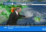
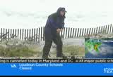
7:26 am
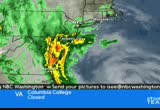
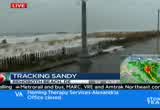
turn around and take just one again. get into the caramel, chocolate and nougat. good morning. welcome to a special edition of hurricane sandy coverage on news 4 today. >> we begin with live pictures from ocean city, maryland. you can see the waves moving ever closer to the boardwalk as the wind starts and the rain continues to fall. >> all public school systems are d.c. and maryland are closed this morning. the same goes for most private schools in the area. the federal government is closed. all nonessential employees should stay home. most major governments are also closed in maryland, virginia and d.c. metro shut down all rail and bus service for the first time since '03. mart also closed.
7:27 am
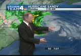
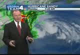
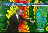
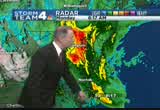
amtrak service also shut down today. you can find a complete list of closings running at the bottom of your screen and online at nbcwashington.com. >> all of this is in anticipation of hurricane sandy and what she will bring and really also to many places inland for hundreds of miles because this is such a monster storm. >> all right, let's check in with storm team 4 meteorologist tom kieran. >> sandy has taken the dreaded left-hand turn, i'm afraid. now it is beginning to take this left-hand turn and come closer. the radar, you can only see about 100 miles off, and the curvature of the earth allows us not to see any further than that. here's the latest track for sandy. we'll get an update here at 8:00. but it's probably not going to change much because we're getting a much better and closer view of what sandy may be doing when it comes ashore.
7:28 am
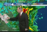
it is narrowing, now, the landfall zone from central new jersey to just south of ocean city, maryland. does look like it's coming to shore some time this evening, after sunset, as a post tropical strong area of low pressure. passing north of washington, going due north up into western pennsylvania. now, here is a close-up look at storm team 4 radar. we're getting bands of heavy rain moving in from the east. we're talking about snow as well. we're getting an ejection of cold air that is moving snow now into southern west virginia, southwestern virginia, and that is continuing to advance off to the north and heading into eastern west virginia. right now, we're dealing with heavy rain. all these areas in orange and red just east of washington. it's going to drift to the west. today, expect the rain increasing, the winds increasing. we could have gusts to 60 miles an hour by 6:00. and then the occasional gust to 70 miles an hour for about an
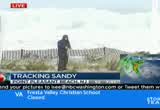
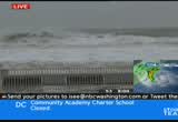
7:29 am

eight or nine-hour period through this evening, into predawn hours on tuesday. that will calls the power outages. that will calls the tree damage. i'm back in just a few minutes with frequent updates all morning long. >> things are quickly going from bad to worse along the coast. news 4 erica gonzalez is there. what's the latest? >> reporter: i want to show you something. remember we talked about the waves breaching the dunes? take a look at this. rocks are already all over the boardwalk here in rehoboth beach. when we talked to the meteorologist, she told us a buoy east of ocean city had track wind gusts at 60 miles per hour and waves as high as 23 feet. look at this. daylight starting to come up
7:30 am

here on rehoboth beach and you can really get an idea of what mother nature is brewing on the east coast. residents -- one man we spoke to yesterday said, my wife is not from miami, she's not accustomed to storms like this. i'm pretty used to hurricanes but to make sure feel safer we decided to go to a shelter. this is the best idea. three shelters open in rehoboth beach. >> no one wants anyone to be harmed, their family, anyone they know. so that's pretty much it. everything else can be replaced, if anything gets damaged. but family and the lives of people are something you can't get back. >> we've got about 20 more minutes before high tide rolls in. if this is the way it's looking right now, you can only begin to imagine what will happen within the next couple of hours now that sandy has taken that left turn into the east coast. live in rehoboth, news 4.
7:31 am
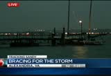
>> it will get even more dangerous for our crews to be on the beach. you guys be safe out there. >> we're keeping an eye on low-lying areas. especially the areas along the potomac where some roads are already shut down. news 4 melissa mollet is live there. >> reporter: it's getting more nasty by the minute. the winds picking up as well. potomac, old-time alexandria, you can see, it is more choppy than this morning. you can see that sailboat in the distance swaying. you can see the dock right there as well swaying a bit. as we kind of look up top, you can see the flags on top of that sailboat getting going pretty good here, as these winds have picked up in the last little bit. this low-lying area, really, really dangerous, because the water at high tides will come up about 8:30 this morning and could flood this area. we have some roads here in old
7:32 am

time alexandria shut down. look at the video we shot this morning. we were seeing how folks are preparing here. you can see folks have put up plastic tarps in front of windows just in case the water -- hopefully it doesn't get that high, if it does, it doesn't seep into their stores through older windows. we have sandbags all over the place. people are boarding up windows as well just to keep that moisture out. some stores shut down last night. say they are not sure when they are going to be reopening because of the storm. so if you can, stay inside today. if there's any way you can just stay home and kind of hunker down and watch the storm from the inside, that would absolutely be the best thing. we will be live all throughout the day. you can watch on nbcwashington.com to bring you the latest. live, melissa mollet, back to you. >> president obama is canceling a campaign appearance in florid
7:33 am

in maryland on hold. voters hoping to cast their ballots before next week's election will have to wait at least a day after governor martin o'malley canceled all early voting for today. plenty of people lined up to get it done before the storm. voting was supposed to go till thursday but it may be extended. early voting has been suspended in the district today. i know at least in fairfax county early voting will not be happening either. >> the storm affecting lots of
7:34 am

our community in many ways. we're here with special coverage of hurricane sandy. >> after a short break, a closer look at when we will feel the winds pick up. anncr: it's said that character is what we do... when we think no one is looking. mitt romney: believe that they are victims. anncr: mitt romney thought no one was looking when... he attacked forty-seven percent of americans. his companies shipped jobs overseas. his plan cuts millionaires' taxes, but raises yours.
7:35 am

he'll voucherize medicare... and make catastrophic cuts to education. so remember what romney said... and what his plan would do. president obama: i'm barack obama and... i approve this message. athat's what the plan georged allen supports... would cost our economy. newspapers called it "economically destructive." like allen's votes to give tax breaks to companies... that ship jobs overseas, his economic plan would...
7:36 am

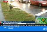
help big corporations, devastating the middle class. allen even voted against tax breaks for small businesses. virginia can't afford to go back to george allen. the democratic senatorial campaign committee... is responsible for the content of this advertising. we are tracking sandy this morning. the storm has forced more than
7:37 am

7,000 flights to be canceled. that's according to the site flightaway. a live picture now, reagan national airport. reagan and dulles both plan to stay open but you need to contact your airline before you go to the airport to catch any flight. if you rely on metro, you're probably not going anywhere for a few days at least. metro has shut down all rail and bus service today. a spokesperson for the transit system says metro will probably be closed at least for part of tomorrow. the last time metro had an extensive shutdown like this was back in 2003 during hurricane isabel. >> and the spokesperson said they'll make that determination later this evening, about whether or not to close metro completely tomorrow as well. we'll bring you the latest on the situation in metro right here on nbc 4. >> we'll talk to tom kierein. tomorrow, you expect things will calm down a fair bit. >> right, aaron. the worst it is going to be
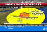
7:38 am
between 6:00 p.m. this evening till tomorrow morning. that's when we'll get the strongest winds. look at the size sandy. this storm, the thing about it, it is covering such a wide expanse, about 1,000 miles wide. the heaviest rains are in maryland and the northern neck of virginia. the areas you see here in the reds and oranges, it's swinging. a lot of tropical moisture west. and now another band coming in off the ocean. and then out farther east there's another band. there's some other areas, very heavy rain. sandy has taken that dreaded left turn now. it is now beginning to head off further to the west. here is the latest track. we're getting an update from this from the national hurricane center. this was probably the very early morning track. it's probably not going to change. this was at 5:00 a.m. so i don't think we'll see much of a change in the tract. i don't think we'll see the
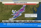
7:39 am

impact zone shrink. central new jersey to south of jersy city. that's where we'll likely see sandy making landfall. we'll have bands of heavy rain coming through and snow out of the mountains and this heavy rain from the east. all these areas in red and orange, a huge area. very heavy rain on the west side of the bay. all the counties east and southeast of washington heading off to the west. as we go forward, we'll have the heaviest rain all the way into this afternoon. this evening, we'll see the rain tapering off. you may get a few wet snowflakes tomorrow evening. the snow will continue out of the mountains. looks like a major blizzard for them. there is a blizzard warning out for all these counties in lavender. that includes garrett county and many of the counties here in eastern west virginia. up to a foot of wet snow, wind driven, with 60 mile an hour winds too. so blizzard conditions.
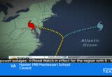
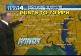
7:40 am
all the rain may be causing flooding. we're getting flood warnings for montgomery. for later today, they're anticipating they certainly will. we'll probably see the whole area lit up with flood warnings. right now, this is a flood watch for today, tonight, into tuesday. high wind warnings. winds gusting to 70 miles per hour later this rn mowing along the eastern shore. here around the metro area, all these counties in color are under that dangerous wind warning for later today. by 6:00 p.m., gusts to 60 miles per hour. between now and then, bands of heavy rain. the gust is 70 miles an hour through the evening. we'll have the heavy rain tapering off tomorrow morning. storm team 4 four-day forecast showing some sunshine finally returning. it looks like thursday, friday, saturday and sunday. i'm back with frequent updates all morning long. aaron and eun. >> thank you, tom. joining us on the phone is myra
7:41 am

opal from pepa. can you bring us up to date on the number of outages for pepco? >> we have seven customers out across pepco so the outages have really not started occurring yet. when they do start occurring, we warn people as these winds kick up, over 35 miles per hour, that that will be unsafe for our crews to go out in our bucket trucks to start restorations. once those outages do start occurring, it may be some time, 24 hours or even more, before we can really begin our full-blown restoration process because of safety issues. >> when we look at your service area, d.c., montgomery county, prince georges county, excuse me, and we consider that the expectation is 50 million people across the -- along the coast will be affected by this storm, what are your expectation, in terms of how wide spread your power outages might be? >> we don't have a number yet but we expect very large outages
7:42 am

and expect these to be several days before we can get people back restored. again, it may be a day or more before we can really start the restoration process. so as people have not prepared, they need to get prepared for multiday outages. the other thing to please stress to your viewers is safety. if they see downed wires, stay away from them. please assume that all wires are energized and to call us at 877-pepco-62 to report downed wire. any wires they see downed, please avoid them. >> we see you've brought in crews from other jurisdictions to stand by. getting ready for this storm. anything else you've done in preparation ahead of this storm? anything you've done differently this time around? >> well, we learned from every single storm, and one of the things we've done is improve our online interface with our customers. we have done an upgrade on our website to make it a little bit more user friendly for our customers so hopefully they'll
7:43 am

get a better performance out of that. that's one of the things we've done. one of the huge things in the storm is we do have crews standing by ready to start a restoration as soon as it's safe for them to go out. >> all right, myra opal from pepco. coming up, with every hour, conditions are getting worse, especially along the coast. here are some live pictures from ocean city, maryland. >> our special live coverage continues after this short break.

7:45 am

what mitt romney's tv ads say about women? or what mitt romney himself says? mitt romney: do i believe the supreme court... should overturn roe v. wade? yes. and it would be my preference that they, that they... reverse roe v. wade. hopefully reverse roe v. wade. overturn roe v. wade. planned parenthood, we're going to get rid of that. i'll cut off funding to planned parenthood. anncr: no matter what mitt romney's ads say. we know what he'll do. president obama: i'm barack obama and... i approve this message.
7:46 am

welcome back. it's 7:46. d.c. residents are gearing up for sandy's impact. that includes neighborhoods prone to flooding. news 4's megan mcgrath. >> reporter: good morning. this is a neighborhood that has seen its fair share of flooding in recent months with just regular storms so with something like sandy there's real concern. this is the cafe, the windows cafe, they brought out the sandbags, piled them up against the door, in the hopes of keeping the water out should it rise. this spot, unit block of rhode island avenue, an area that has flooded several times here. so of course everybody keeping a close eye on this storm. because when it happens, it happens fast, and we haven't yet seen the really heavy rain we're
7:47 am

expecting. we've seen people out and about. among those out here this morning, keith, you're a little upset that metro is closed today. >> yes, ma'am. they kind of jumped the gun on it. it's only rain right now. people got stuff they got to do, you know, it's like everybody can't get out here like me. i walk with the lord. so everybody can't get out here, you know, people got kids and stuff. what about the baby-sitters and -- you know, kind of jumped the gun. maybe tomorrow when it hits. but it's just some rain, you know, make d.c. look like a little sucker city, you know? >> reporter: all right, keith, we'll let you keep walking. take care. so some folks have to work today. plenty of folks don't have to work. federal government, d.c. government, they're closed. d.c. schools closed today. there are plenty of folks who will hunker down at home and stay dry. unfortunately, not everyone. people like keith who have places to go. unfortunately, don't have the
7:48 am

transportation to get them there. both metro bus and metro rail closed. and it's unclear exactly when service will run again. basically, they're concerned about standing water. they're concerned about the wind bringing down trees and damaging the tracks. they also need power in order to run the system. so they're taking all of those factors into account. made the decision to close. we're going to have to wait and see when service will resume. reporting live in northwest, megan mcgrath, news 4. >> dominion power says it is prepared. it has trucks ready to be dispatched from its springfield office. it has commitments from 2,000 outside crew members to help restore power after sandy moves out town. about 660 power outages now. pepco says it is prepared to restore power after sandy blows out of town. it has hundreds of crew members in town from across the country to help with that restoration effort.
7:49 am

news 4's tony tull joins us now. >> reporter: they were checking equipment, making sure everything was working okay. they had about 400 contractors they secured outside of pepco as well as putting in that mutual assistance. that request was answered very largely. take a look behind me at the fairgrounds. you can see hundreds of trucks. as well as north carolina power companies. bringing trucks, crews, equipment. everything you can imagine to come assist pepco in their need for service calls when these mass power outages are expected to hit. we saw some of them about a half hour ago start their trucks up. moving the booms up and down. they said they were just grabbing their trucks and taking them back ton the hotel. some of them were on call for this morning. they weren't being dispatched anywhere but they just needed to
7:50 am

have their trucks if they got the call from pepco. about 400 independent contractors as well as hundreds of other trucks from north carolina, arkansas, as well as alabama. alabama power even bringing three of their mobile command centers here to the fair ground. again, you're right, this is just the staging area. they will be dispatched as pepco needs them. a very impressive sight. many trucks here at the fair ground to assist. one of the things you brought up earlier we also want to touch on, a lot of these guys will not be working in high wind situations so if you have a power outage, you have to wait for these guys to get out. we're live in gathersburg, tony tull, news 4. hundreds and thousands of people are hunker down for sandy. mike sidel is live in new jersey. >> reporter: things are going downhill fast here. we're getting gusts now 40 to 45
7:51 am
miles per hour. it's going to come in south of here, so we're right here in the area that's going to have the highest surge at least on the new jersey coast so maybe higher numbers up the long island sound because of the way long island sticks out and the way the coast is configured. here, as much as 8 feet. the surge coming up over the wide dune. we just had a wave come up here. look at the surf out there. this is one angry atlantic. a hurricane that feels more like a nor'easter. it's a bit of a chill out here with the wind and rain and stinging sand. high tide coming in this evening about 8:30 on the jersey shore. that's our next and probably the worst case scenario because the storm is going to be to make landfall about the same time. high tide, high surge, and the full moon. all three factors going to make the situation worst. >> i can only imagine the people there. what are they doing to get ready
7:52 am
for sandy? >> reporter: wow, look at this wave that just came up behind me. this one breached the dune and came up. everybody boarded up over the past couple of days. just about everything is boarded up on the coast. a lot of these are weekend summer homes and a lot people had planned to go back to their monday through friday addresses on sunday anyway. the town is pretty quiet coming over here across the street. i didn't see any cars up and down ocean avenue which is the main drag here in point pleasant. erb's hoping it's not going to be as bad as irene but very likely it will be, just based on the direction it's coming in. we had some damaging issues. this is going to pile the water up for a long time. 8:30, that's going to be the
7:53 am
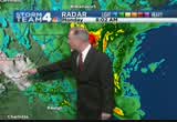
crux of how much damage we get, surge damage. then we'll have the wind to deal with. inland, all the way to d.c. of course. back to you. >> mike sidell, live in point pleasant beach, thank you. >> tom kieran now. we showed people a lot of pictures from the coast but we don't want folks to get lull noodle a false sense of security for those of us who are more inland. it's going to be rough on us as well, right? >> yeah, this is a multifaceted storm. it has affected in different areas. i'll try to sort it out. the big story is that it is such a big storm. it covers a 1,000-mile wide area. as we've been seeing here in the last couple of hours, it has begun to take this turn west. head of it, by the way, it's about the center circulation. 400 miles from washington. look at this. we're already seeing some of the heavier rains moving in. now the track is bringing it ashore from the central jersey coast down to just south of ocean city. it may come in anywhere in this
7:54 am
zone. perhaps just after sunset tonight. by then, it will be a post tropical strong area of low pressure, passing just north of the metro areas. right now, we're getting this heavy rain. these areas in dark orange and red. also these areas in white and pink. that's snow, southern ohio, down to southwestern virginia. for us now, locally, our eastern suburbs, counties along the bay, getting pounded with very heavy rain. not a lot of wind yet. winds only 20 miles per hour. also the heavy rain around the tidal potomac. it is tracking to the west. this area of the heaviest rain moving through. this is the circulation of sandy passing north of us. actually may draw in some cold air out of the mountains. maybe even give us a few wet snowflakes here tomorrow morning. don't be surprised if you see that. the big story is we'll have the winds diminishing quickly tomorrow as far as the long
7:55 am

distance future is concerned. we'll have continued snow in the mountains but drying conditions. the sandy potential wind by 8:00 p.m. will gust to nearly 70 miles an hour throughout our region. the wind gusts through the rest of the evening, to tomorrow morning, will gust over 60 miles an hour. that's when we'll have the wind damage, the power outages. back to you. >> all right, tom, thank you. across the area, first responders also getting really to spring into action as soon as they might be needed. one of them, the chantilly-based virginia task force one, it was activated last night. 80 personnel many mobilized there. >> we're keeping an eye on low-lying areas. especially along the potomac where some roads are already shut down. news 4 melissa mollet is near the potomac river, alexandria. how is it looking now? >> reporter: i know, you know, right now, we're looking okay,
7:56 am

bub i know high tide comes in at 8:31 this morning, and then again at 8:41 tonight. you can kind of look at the water right here and see that it has risen quite a bit from what we were dealing with earlier, obviously. what we understand is that we could get 1 to 2 feet higher than what is normal for this area during a typical high tide. so we definitely could get up over the sidewalk where i'm standing. and then flood up prince street, which obviously happens a lot. you can also see this boat here in the distance. and the dock it's attached to here, swaying just a little bit. you can see that the current is really kind of moving a bit. we have a little bit of wind coming through here right now. i think rain has slowed down. just the slightest bit. so we have a nice little steady drizzle now that's pelting down. we've been talking with some folks as they've been walking their dogs this morning. one woman we spoke with has lived here on prince street for a long time.
7:57 am

she's lived in old town alexandria she said for 40 years. she said when she saw isabel come through, there were people in can ooups, remember that. and boats stuck on roads down the street. she says she thinks this is going to be worst. live in old town alexandria, melissa mollet, news 4. our special coverage continues. we have reporters standing by live on the coast, in d.c., in virginia and in maryland. >> stay with us.


8:00 am
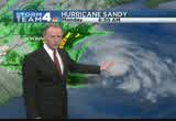
good morning. welcome to a special edition of "news 4 today" for special hurricane sandy coverage. good morning, i'm eun yang. >> i'm aaron gilchrest. these are live images from ocean city, maryland. you can see the surf crashing, the waves crashing on to the shore there, and even up to the boardwalk in some parts. reports wind speeds topping out in the area of 69 miles per hour. >> tom has said later today ocean city and parts of the eastern seaboard will experience hurricane force winds. people there already evacuated or boarded up their homes. it could be a very dangerous situation as you can see from these live pictures. >> here's how things stand right now at 8:00 a.m. all the major public sool systems in d.c., maryland and virginia, they're all closed
8:01 am

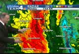
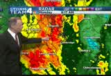
this morning. the same goes for most private schools in the area. also, an important note, the federal government has shut down the d.c. area offices. all nonessential employees should stay home. most major local governments also closed in maryland, virginia and in d.c. of course. metro, metro shut down. all the rail and bus service. first time that's happened since 2003. mark vre also closed today and amtrak has closed service along the eastern corridor today. you can find a complete list online at nbcwashington.com. >> we just showed you the winds whipping up in ocean city. meteorologist tom kieran has been tracking the path sandy. we want to know how bad it's going to get. >> we look closer to the center of circulation. there's a buoy about 50 miles east of ocean city. this buoy is reporting waves of 23 feet and wind gusts to 60 miles an hour. and that's only going to increase as we get into the
8:02 am
afternoon. and those 60 mile an hour gusts, they're getting closing to the coast here shortly. right now, the peak gusts generally from louis, delaware, down to acoteague. the peak gusts will increase as we get into this afternoon. the center of circulation is over 400 miles away, but here we are feeling the effects of sandy in the form of heavy rain moving through the metro area , and it midwest, and that is changing the rain to snow here in west virginia. rain/snow mix. it's snowing in southwestern virginia as well from near blacksburg. that cold air is going to get wrapped into the system and advance farther to the north and bring in blizzard conditions for eastern-western virginia. for us, we have to think about flooding. there could very well be creeks starting to come out of their banks. st. mary's and perhaps even
8:03 am
parts of charles and eastern prince georges county right now. and there's more rain to come. right now, around the metro area, where you see the yellow, here's the intensity scale. that's moderate rain in washington, most of montgomery county, most of fairfax county, prince william, and stafford in pennsylvania. further left where you see the green, that's light rain. it's going to be coming in bands. this is the biggest band of the storm so far and it's moving inland. there's a more narrow band crossing now, just about to move into the bay, and moving west of the eastern shore. there's another band off the coast here too. we're going to get band after band. they taper off for a while and you may think, oh, it's other. but then it's going to increase again. it is rains will come and go as we get into the afternoon. it's going to continue for many hours. 5 to 10 inches of rain total. that will bring creeks and streams out of their banks.
8:04 am
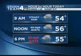
dark green areas are under a flood warning. seneca creek likely getting out of its banks. later today, the creek in frederick county. that snow has prompted a blizzard warning, of all things, here in late october, for western maryland, garrett county, through these counties in eastern west virginia. in effect through the rest of the day today, tomorrow, maybe wednesday morning, may continue to get the snow, up to a fast heavy wet snow, wind driven as well well, may be near whiteout conditions. there's a huge area under a high wind warning and covers our whole area, the district, all of maryland, the eastern shore. jersey, all across pennsylvania. wide area. we'll have gusts to 70 miles per hour. here are the gusts now. ocean city had a gust of 37. virginia beach, 41. these will be increasing as we get into the afternoon. the peak gusts around the metro area have been around 30 miles
8:05 am
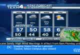
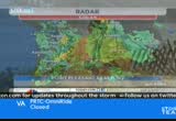
an hour over the last hour or so. hour by hour, we'll continue to have the winds increasing. the rain bands coming through from time to time. by 6:00 p.m., right here in the metro area, we may have gusts to 60 mile always hour then, perhaps even higher gusts through the evening. 8:00 p.m., 10:00 p.m., midnight, gusts to 70 miles per hour off and on and sustained winds bat 40 miles an hour. so trees may topple. weaker branches snapping off causing power outages and widespread tree damage and prepare for long duration power outages. many days, maybe, without power, even though we're going to be drying out, end of the week. seven-day outlook showing sunshine coming back thursday, friday, saturday sunday. the last of the rain is really tapering off tomorrow afternoon. maybe a lingering shower on wednesday morning. i'm back again. i'll be here with frequent updates throughout the morning. dan nell la's here now with a look at the traffic. >> right now, seeing problems
8:06 am

already, northbound 395 shut down. this is because of a serious accident as you travel in the crystal city area. making your way to crystal city, northbound 395, all lanes blocked. let's talk about wind damage. a downed wires, in jessup, race road is closed in both directions at monticido. still very wet conditions. in anticipation of flooding in bethesda, river road is completely blocked. this is at little falls parkway. aaron and eun, over to you. >> thank you, danella. pepco says it is as prepared as it can be for sandy. >> like many of us, its crews have to ride out the storm before jumping into action. our team coverage continues with tony tull who is live at the montgomery county fair grounds in gathersburg. >> reporter: good morning. one thing you said, that's right, they'll have to wait this storm out because these high winds everybody's talking about, up to 60 miles an hour, the crews cannot operate in those kind environments. they can't put the booms up and
8:07 am

start making repairs in those kind of conditions. but like you said here at the montgomery county fairgrounds, i want to show you how prepared pepco is attempting to be for these mass power outages that we've been talking about all morning. last week, they put out a mutual assistance call for power companies around the region. you can see, an astonishing amount of power trucks and crews here that have come to aid pepco when we do get power outages. crews from arkansas, crews from north carolina, also alabama, power companies sending many crews as well as some of their communication centers. they have satellites. so they set some mobile command centers up as well. a lot of power companies throughout our region have sent crews out to assist us once sandy does, in fact, calm down. last time we checked, it was about 400 independent contractors on top of these crews. so this is quite the turnout we're having. just a quick fact, we got here
8:08 am

about 3:30 this morning. there was a fuel truck fueling some of these trucks up. he has, since this morning at 3:30, going through 5,000 gallons of diesel fuel. so that gives you an idea of how many trucks are out here. he's getting some more fuel and coming back. some of these guys have picked up their trucks and headed out. they're actually picking up their trucks and they're taking them to the hotels. a lot of them are still on mandatory rests from long drives. so it's pretty amazing site to see, the request call being answered by many of our fellow power companies out in the region. we'll continue to stay on this out here in gathersburg. >> question for you. in addition to the trucks that you see on site there, any idea if other types of equipment being moved into that same staging area, power poles, for example, anything of that sort. >> reporter: they have a lot of big generators. they also have a lot of industrial commercial sized
8:09 am

lighting. the ones that run off gasoline. they have brought a lot of different apparatuses and different pieces of equipment to assist crews as they go out and make a lot of repairs to when these mass power outages are coming. there was two 18 wheeler trucks that came in. one came in early this morning, dropping off other needed supplies. they'll be well prepared once they hit the roads and start making these repairs. >> lots of people too, people who will physically get in the trucks. all right, people here in d.c. are break out the sandbags and boarding up windows. >> especially in neighborhoods prone to flooding. you see megan mcgrath live in the bloomington section of the district. >> the union block of rhode island avenue, this is one of the trouble spots. with just regular storms, it has flooded. you can see residents here, they're not taking any chances. with the kind of rain they're talking about that's associated
8:10 am
with sandy. the businesses have put the sandbags down hoping if the floodwater comes it at least won't go into their businesses here. some who live in this neighborhood say that's wishful thinking, because there have been so many problems. i will say the district has been out this weekend. they were cleaning the storm drains. removing debris. getting some leave, os out of t way to make sure storm drains are working properly. because we are expecting some incredible rain in the not too distant future. we've had light to moderate rain thus far. we haven't seen the heavy downpours as of yet. as you've been hearing, it is, indeed, coming. a lot of folks are nervous about exactly what's going to happen. actually, one of my friends, olivier, you live in the neighborhood, with your lovely dog. first, your thoughts on what you've seen so far, and are you worried at all about flooding?
8:11 am

>> this area is known for flooding, so a little bit, especially at this time of the year with the leaves. there's leaves everywhere. so i think it's going to clog the drains. so far, so good, you know, just rain. >> reporter: are you doing anything differently today? >> as you know, i don't work on mondays. no, i just got the house ready. the city gave us some sandbags. so i put some sandbags in front of the house. went up the roof, clean out the gutters. take care of a couple of things in the backyard. that's about it. now, as long as we have poushwe we can watch tv, watch the news, see you. we're waiting. >> reporter: what about the neighbors? is it pretty much the same scene, the sandbags? >> yeah, it's become routine now. i think the rain is going to be okay. everybody know what they have to do. i think the wind, the wind is what's worrying the people, the trees, the huge trees in my back
8:12 am

yard, my neighbor's back yard, so that's what everybody's worried about. >> reporter: who is this guy here? >> this is max. >> reporter: max seems to be enjoying the rain. the few out there enjoying the rain. >> no matter what, max loves to be outside. >> reporter: all right, we'll let yowl get dry. thanks for stopping by, take care. so you can hear, the folks in this area, this is kind of a routine drill. they've seen it before with all kinds of storms. they get the sandbags in place. they raise things up off the floor. they basically don't use their basement. they have a few things that are kind of hanging from the rafters up high. they don't have anything down on the floor in this area because it's been such a problem. again, we are expecting torrential downpours to begin soon here in this location. a lot of folks nervous not just here. there are other low lying areas
8:13 am

in the district. georgetown prone to flooding. we were down by washington harbor. that floodgate they have that surrounds that development, those floodgates are running. the embassy that's next door, they have their flood gates up as well. so people doing what they can to prepare. but the bottom line here is there's only so much you can do. yeah, you can put those sandbags in place. but depending on how much water comes, they may or may not hold the water, keep the water out of your house and business. reporting live, megan mcgrath, news 4, back to you guys in the studio. >> conditions are worsening in many beach towns. >> now the tides are going to start to play a role here. rehoboth beach has already reached high tide. >> reporter: welcome to high tide on rehoboth beach. we just had a big push of a wave
8:14 am

come through here. i want you to take a look at this. rocks all the way up. this is our hotel right here. sandbags lined pup boarded up windows. look at the rocks. they already came up to the doors. this is our hotel management that's been keeping us safe and warm with coffee and blankets. everybody else is evacuated. they're sticking around to help us. look at these waves. the rain's coming down. still gusting 45 miles per hour. it's cold. it's only going to get colder. one of the buoys about 50 miles east of ocean city reporting waves as high as 23 feet. these are huge. and this is only the tip of what this monstrous freak of nature we are calling sandy is expected to do here along the coast. take a look at the fences along the dunes. already coming down here. this is just picturesque of
8:15 am

mother nature. of what these waves can look like and what it can do. rehoboth beach bracing for a not good morning. still much more to come. we are live in rehoboth beach. erika gonzalez. >> i can imagine you don't see many people, besides the people who are working at the hotel? >> reporter: no, the governor of delaware has made it -- very aware that it is illegal for folks to be on the road as of 5:00 this morning. there is nobody allowed on the roads right now. everybody needs to be in their homes. if you live within three quarters of the mile of the beach, there was a mandatory evacuation in place up to 8:00 last night. several people already in at least one of three shelters here in rehoboth beach. >> erika gonzalez, live on
8:16 am
rehoboth beach. thank you. >> the fact of the matter is, she's not being dramatic, it is something that meteorologists alive right now have not seen before. >> 1,000 miles, is that right? >> yeah, that's about the width of the storm. we're 400 miles away from it, we're gettinging heavy rain. look at those big breakers coming in. as erica said, that buoy, east of ocean city, reporting 25 footers. just off the beach. pushing water inland there. high tide there now. it's exacerbated by a full moon which will keep the tides abnormally high. it does look like for the next couple of days, even after sandy goes by. well, take a look. here's the center of circulation. since we came on at 2:00 this morning, i've seen sandy take a turn from the northeast to north and now heading back to the
8:17 am
north and west. it does look like, now, it has made the dreaded left turn, and it is looking like it will track anywhere between ocean city and central new jersey. that's later today. you can see these waves here on the radar. the heaviest wave of rain right now is right over the washington metro area. here is the very latest track. this just came out. the very latest track. it really hasn't changed much. coming ashore anywhere from right near ocean city here up to the central jersey coast. so this is going to be the zone where the center of the hurricane comes ashore. because it has such a wide extent, it's going to be affecting weather from the carolinas to new england. the heavy rain band about to move in to washington. also, we're getting snow. this area in white on storm team 4 radar is snow. snowflakes around blacksburg,
8:18 am
southwestern virginia, and then into west virginia, to charleston, they're getting that snow. the cold air will advance farther to the north. blizzard conditions are going to be moving into the mountains later today and into tonight. but now for us more immediately we've got this big band of very heavy rain that is advancing to the west. right now, about to cross into, again, this is like the second wave for the western shores of the bay. and the first wave that did come through about an hour ago is just about to come right into washington. these little batches of orange. that's where it's coming down hardest right now from near severn, annapolis, shady side, they're getting heavy rain. farther south, pockets of heavy rain, st. mary's county, across the tidal potomac, getting very heavy rain. we're getting low to moderate rain in the metro area. we're in the yellows here. up into montgomery county and
8:19 am

farther west, fairfax, into loudon county, around the blue ridges, some lighter rain, but it's coming your way. here's washington. here's the bay. here's the atlantic seaboard. all these areas in the yellows and oranges and reds, those are the areas of the heaviest rain. here's the circulation of sandy passing just to the north of the metro area. late tonight, into tomorrow, it may draw cold air in. this is as of 6:00 on tuesday morning. we might have some wet snowflakes flying in the air here after the heavy rain ends later tonight. and then the snow continues out of the mountains. all through the day, on tuesday, tuesday night now wednesday. acoup lating snow continuing there. that will finally taper off by wednesday night. but here are the expected winds. this is as of 8:00 p.m. today. we could have winds gusting as high as 70 miles an hour. all this area in red.
8:20 am

it covers northern virginia, maryland, parts of eastern west virginia, gusts of 70 miles per hour at 8:00 this evening. we'll have gusts over 60 miles an hour through a huge area. that's going to be the time that the snow will be falling out in western maryland. they're going to have near whiteout conditions with wind driven snow. meanwhile, as we get toward the predawn hours, the winds will diminish. 1:00 tuesday morning, 1:00 a.m., gusts around 60 around the metro area. by 3:00, we'll begin to see wind relaxing. by dawn tuesday, the winds diminish. the rest of the day, they'll continue to weaken. rain, that's the other huge part. creeks and streams out of their banks. all these counties in green are under a flood watch. today, tonight and tomorrow. we'll probably have a lot of
8:21 am

warnings coming up as well. we also have the blizzard warning, all these counties in lavender. wind gusting to 70 miles an hour. this is the high wind warning region. current wind gusts are around 30 miles an hour locally. it's near 40 along the coast. it's going to increase this afternoon. ocean city had a gust of 35. new york city had a gust of 37. virginia beach, 41. hour by hour, increasing winds and rain bands coming through. 60-mile-an-hour gusts by 6:00 p.m. through the evening, that's when we'll have the wind damage, the power outages. forecast, improving on wednesday, thursday, friday, saturday and sunday. we'll still be dealing with power outages and the recovery. i'm back in a few minutes. >> i want to ask, an opportunity here to educate, because there's so many things about this storm that just don't make a whole lot of sense.
8:22 am
erika talked about the fact that it's cold where she is in delaware. you're talking about the potential for snow here. tropical weather is supposed to be warm, right? >> yes, usually. but here we are, we're late october. the waters are warm in the atlantic. the gulf stream waters are still warm. so it's feeding off of that. you can see these bright areas, these are the clusters of very heavy rain and thunderstorms. it's still feeding itself. here, we're under much chillier air. when that rain comes in, it makes you feel even chillier. drawing in cold air from the midwest too. it's more of a hybrid hurricane, not a typical one like we see late summer and early fall. >> that canadian weather. tom, thank you. we appreciate that. >> stay with us. we're continuing to cover hurricane sandy from all over
8:23 am

the region. we have live crews in ocean city here. this is a live look at crashing waves and ripping winds. anncr: five hundred and thirty seven. the number of votes that changed the course of american history. newscaster: florida is too close to call... anncr: the difference between what was... and what could have been. so this year, if you're thinking that your vote doesn't count. that it won't matter. well, back then, there were probably at least 537 people... who felt the same way. make your voice heard. vote. president obama: i'm barack obama and... i approve this message.
8:24 am

and this is maryland. teacher: this is west virginia, pennsylvania, delaware. every year marylanders spend five hundred and fifty million gaming at casinos in these other states. question seven will build a new casino and bring table games to baltimore... generating hundreds of millions for schools. and that money has to go to education. it's the law. so vote for question seven. so we can stop spending all that money here, and keep maryland money in classrooms like mine.

8:26 am

welcome back. you're look live at rehoboth beach, delaware, where the waters are rising. some have already hit the store fronts. this is high tide just a few minutes ago. >> the beach is already underwater for all intends and purposes. waves have been crashing up on to the boardwalk, erika gonzalez has been telling us. the town has been evacuated. people are not allowed to drive in the state of delaware at this hour. and don't know when that will be, when that will change, when the governor will let people drive again. you see the water right up the pier. >> those store fronts have been boarded up. people evacuated. people are ready and trying to heed the orders to get out of the way or just stay indoors. we were going to continue following live coverage. let's check in with diella.
8:27 am

>> as you make your way toward boundary channel drive, all your lanes are blocked. it's windy, just shaking the camera. what happened is a four-vehicle accident. two people trapped inside. this is going to take a while to clean up. the best bet, if you have to get on the road and take 395 heading northbound, you have to get off at route 1. also, the wind, very windy. so downed wires shuts down race road and just keep in mind that also we're looking out for high-standing water. so if you're traveling along little road, you'll see little falls parkway, all your lanes are blocked. >> another area we're watching closely, right along the potomac river. >> some roads in alexandria are already shut down. news 4 melissa mollet continues our coverage from old town alexandria. high tide within minutes. >> reporter: just a couple of
8:28 am

minutes, 8:31 is high tide. it is much higher than it has been of course, which of course is expected. at this point, not coming on to this walkway where i'm standing. sometimes when the river gets very high like this, when we have a lot of rain or even a quick snow amount, it can still go into sewers and such and get on to the roadways. that is something people will have to deal with. we've been talking with a lot of folks this morning. some people taking a look at things this morning. we spoke with one woman who says she has lived here in old town for 40 years and so far isabel has been the worst but she's very nervous about this storm. take a listen. >> i saw the water go over the fire hydrant, i thought, uh-oh, that's a problem. and the next day there was a boat down in the park. i've seen some pretty bad things. lots of canoes, that type of thing. >> how do you think that will compare? >> from everything i've heard,
8:29 am

it's going to be worse. because of the combination of the nor'easter, the hurricane and the cold weather from the west. pretty scary to me. >> so the rain coming down probably as hard as it has come down. it is quite drenching to be outside. definitely stay in, if you can. you can see the water here, quite choppy. that boat in the distance not moving really as much as it was earlier, you know, because of the water moving, because of the wind, but it is still rocking along with that dock quite a bit. we'll keep you updated on any issues here, live in old town, melissa mollet, news 4, back to you. >> sandy creeping towards the coast. conditions worsening along many beach towns. >> erika gonzalez is back out at rehoboth beach this morning where she's been hunkered down. that doesn't mean the wind and
8:30 am
rain are not battering you now. >> reporter: no, it doesn't, aaron, good morning. this is monday morning here at rehoboth beach. look at the swells. they are just -- i mean, it's beautiful, really, to look at, and it's hard to keep your eyes off it, but it has been coming in here to the boardwalk. this is only going to get worse. we're trying to show you each and every shot. there it is. take a look at it. this is just the tip of it. we're going to see a lot more of this and bigger, more, lots more water. lots more rain. there is a driving band here in rehoboth that was issued on behalf of the delaware governor as of 5:00 this morning. nobody allowed on the roadways. that's going to get you a citation. the best thing to do is to be inside your homes, if you are not already inside a shelter.
8:31 am
look at the dunes. well breached. defenses are down. some have floated into the distance because of the immensity of these waves, 7 and 9-foot surges. by midnight tonight, we're expecting 8 to 11-foot storm surges here in rehoboth beach. and we're talking about the difference between this storm, aaron, and other ones -- whoa. is how cold it is out here. the sand just picking up and being thrown into your face. much different than a lot of the other storms that we've covered because of the circumstances, because of the condition, because of the frigid temperatures. and it's only going to get worse. in rehoboth, erika gonzalez, news 4. >> earlier, you showed us the water reached the store fronts.
8:32 am

so far, are the preparations holding up? >> reporter: as of now, yes, as of now, yes. this morning has really been the first signs that we've seen the water breach the dunes. till about 15 minutes ago was the first time we saw it reach the windows and the store front here of this hotel. it's only, what, a few minutes shy of the 9:00 hour. come noon time today, we can only begin to imagine what this is going to look like. as the day progresses, we're expecting hurricane force winds as early as this afternoon. >> we know we report to people who stay, board up. we also reported where you are, people have left for the most part. for you and folks who are staying there, what are you doing to try to keep your safety in mind and not find yourself in harm's way? >> you know, we've made sure that all of the windows are
8:33 am

closed and the curtains are closed. so if in case the windows should shatter, they are taped up, but if they should shatter, you've got something that's still in front of them, shielding you. we've got plenty of warm blankets. and we can't believe how amazing the staff has been. everybody else has evacuated. they have said they will stay here with us to make sure we're okay. so we're really thankful of everything they're doing. >> erika gonzalez, rehoboth beach, delaware. >> thank you. thousands of flights are canceled. >> nbc's tom costello is at the national airport. we know it's having a big impact. >> you look outside, the ramp is empty. that's the way it is across the
8:34 am

entire airport. that's it. in fact, the police chief walked by a minute or so ago. up and down the eastern seaboard, we're talking about 7,000 flights canceled. from yesterday, today, tomorrow. they hope they get back up and running on wednesday. maybe late tomorrow. then the problem is we're talking about all the major carriers. southwest airlines. when you've got all those major players affected -- by the way, seven hubs, you can see the rip t ripple effect. as a result, when they move them, then you create a situation where you've got planes and crews out of position. even though they may start
8:35 am

flying again on wednesday, it could take days before everything gets running. washington reagan, washington dulles, baltimore, philadelphia, big-time affected, as well as all the new york city airports, jfk, la guardia, newark, then even hartford affected this morning. as the storm moves further inland, you can expect some of the airports further inland will also be affected. conceivably you could see cincinnati affected. you could see louisville affected. we'll see where the storm goes and what the trajectory is. it is going to affect a large number of passen gerbs who had hoped to be moving today. amtrak service also shut down on the northeast corridor. in addition to everything happening locally here with the metro system down and the new york city system down, the subway system down, you've got all airplanes grounded and the amtrak situation also is suspended. >> you mentioned that ripple
8:36 am

effect. how long before passengers are going to be able to get on their flights? it could be weeks, maybe days, because everyone is scrambling to get the flights they missed in the next few days because sandy. >> the airlines are waving their change fees or rebooking fees so you shouldn't be hit by that. you're right, just because they're back up and running on wednesday, it doesn't mean that your plane is going to be sitting here at the ramp ready to take you. part of the problem, as you well know, is all these planes are flying full these ds and the airlines have very little slack in the system. this isn't like ten years ago when they have lots of extra room. today, the airlines are flying very lean and as a result, when this kind of a thing happens, they don't have a lot of extra slack to pick up the room. >> tom costello, thank you. >> tough for travelers for sure. >> we want to go back to nbc 4
8:37 am
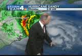
meteorologist tom kieran. >> we have sandy spinning away off the coast. we are about 400 miles away from the center. you can see it's affecting another 400 miles farther to the east of the center. perhaps another 400 miles farther west. there's a lot of rain and wind. look at the very last update. the first daylight view from the satellite. these very bright areas here. these are bunches of very heavy rain and thunder and lightning. this area of really heavy rain, this is what's going to be rotating around and coming right on up our way. now, much of the eastern shore has already had about 3 to 4 inches of rain. some locations, even a little bit higher. many creeks and streams already likely coming out of their banks there. just east of ocean city, there's a buoy out there that has recorded waves as much as 20 to
8:38 am

25 foot waves. in fact, up near the center of the storm, there's another buoy way out there, there are 42 foot waves. look at these waves coming into ocean city. this is an awesome event in nature. let's just watch and listen. huge breaker just came in. look further out, almost on the horizon. some of those waves are at least 10 to 15 feet. you can see as soon as they break the winds grab the spray and whip it. look at this huge breaker coming in. this is right at high tide too.
8:39 am
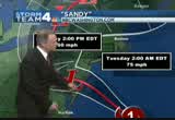
so this is pushing a lot of water on to the beach. it's causing a lot of beach erosion. live picture there from ocean city. we'll show you more of that as the day progresses. it is quite a massive storm. the latest track is showing that it is going to be moving inland. after sunset, it's coming ashore. anywhere in this zone which is getting smaller because we're getting a much better idea. from central jersey to just south of ocean city. doesn't matter too much because the storm has such wide effects, it will be affecting the weather from north carolina all the way to new england. as it does come inland, it's going to be packing winds of 70 miles per hour. by dawn on tuesday, some gusts could be around 60 miles an hour. getting heavy wind in washington. points east, they're getting
8:40 am

snow in southern west virginia. the heavy rains are now near annapolis, right a long the western shores of the bay. another batch of heavy rain in the western part of the northern neck. right around washington we're just getting some light to moderate showers but we're going to continue to see waves coming through. more to come from way off the coast coming our way. as we look at the future weather. we'll have this area moderate to heavy rain continuing to dawn tomorrow. a lot of the rain will taper off. a few wet snowflakes in this area of blue. tomorrow, into wednesday, they're going to be seeing a major snow event out in the mountains of western maryland, much of eastern west virginia. winds, most locations will have gusts to around 70 miles per hour. by 11:00 p.m., 65-mile-per-hour gusts. after midnight by 1:00 a.m., still around 60 to
8:41 am

65-mile-per-hour gusts. a lot of tree limbs coming down. then by dawn on tuesday, we'll have the winds greatly diminishing. maybe just a few isolated gusts around 35, 40, especially around the bay. a lot of rain. enough to cause flooding. dark green areas, flood warnings out for montgomery and frederick county, creeks likely coming out of their banks later today, flood warning there. the blizzard warning is for the mountains, western maryland. 6 to 12 inches of snow. whiteout conditions. winds blowing 60 miles per hour out of the mountains. high wind warning from right now, all the way till 8:00 p.m. tuesday. again, the peak gust time does look to be later this evening. right now, here are the latest gusts. peak gusts around 25 to 30 and it's only going to worsen. peak gusts from the storm along the jerlsy coast have been over
8:42 am
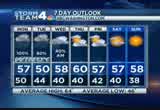
40 to 50 miles per hour. virginia beach up to long island getting some really strong winds. hour by hour today, expect increasing wind and rain bands coming through. we'll stay in the 50s throughout the day. 70-mile-an-hour gusts, that's when we'll have the wind damage. that will be around 6:00 p.m. to tomorrow morning. then the weather improves as we get into wednesday, thursday, friday, saturday, sunday. some sunshine back. and we'll be dealing with prolonged power outages. we don't know how many days. maybe weeks for some people. back to you. >> that's right, tom, thank you so much. that's right, pepco spokespeople are saying, listen, the storm has to pass for it to be safe enough for crews to get out. >> to do the assessment. and then the repairs. >> pack your patience for sure. >> let's look at live pictures from virginia beach, virginia. we've talked a lot about what's happening north of the district. look at these waves hitting the
8:43 am

shoreline there in virginia beach to our south. >> incredible. we can only imagine the kind of damage these waves and the gusting winds which are rapidly picking up are going to cause on the pier. we're live, we'll bring you the very latest right here on nbc 4. anncr: it's said that character is what we do... when we think no one is looking. mitt romney: believe that they are victims. anncr: mitt romney thought no one was looking when... he attacked forty-seven percent of americans. his companies shipped jobs overseas. his plan cuts millionaires' taxes, but raises yours. he'll voucherize medicare... and make catastrophic cuts to education. so remember what romney said... and what his plan would do. president obama: i'm barack obama and... i approve this message. athat's what the plan georged allen supports... would cost our economy.
8:44 am

newspapers called it "economically destructive." like allen's votes to give tax breaks to companies... that ship jobs overseas, his economic plan would... help big corporations, devastating the middle class. allen even voted against tax breaks for small businesses. virginia can't afford to go back to george allen. the democratic senatorial campaign committee... is responsible for the content of this advertising. prand you're seeing that rightno quit in amnow.a... over five million new jobs. exports up forty one percent.
8:45 am

home values... rising. our auto industry... back. and our heroes are coming home. we're not there yet, but we've made real progress and the... last thing we should do is turn back now. here's my plan for the next four years: making education and training a national priority; building on our manufacturing boom; boosting american-made energy; reducing the deficits responsibly by cutting where... we can, and asking the wealthy to pay a little more. and ending the war in afghanistan, so we can... do some nation-building here at home. that's the right path. so read my plan, compare it to governor romney's... and decide which is better for you. it's an honor to be your president... and i'm asking for your vote... so together, we can keep moving america forward. i'm barack obama and i approve this message.
8:46 am
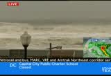
welcome back at 8:45. these are liv pictures of ocean city, maryland, right now, where the winds are whipping up. winds whipping up, waves crashing. we understand part of the pier may have been damaged in ocean city because of the strength of this storm that's continuing to strengthen and becoming more violent. >> we've gotten word that the annapolis harbor is now closed as a result of what we are seeing in these pictures from ocean city. this is something playing out all up and down the eastern seaboard. >> as this storm picks up, more areas shutting down, more evacuations. let's check in now in new jersey where folks there are bracing for sandy as well. >> they have declared a state of energy in new jersey. suspended all public transportation in that state. nbc's danielle lee live at cape
8:47 am

may, new jersey. >> reporter: good morning. we're still getting dumped on with this rain. the big change, the sun has risen. our first good look. look at these violent waves. the sand is almost covered in the water because of the rising tides. the waves are much, much longer. experts are predicting this tide could rise up to 8 feet. that's why they're so concerned about flooding. we're already hearing reports of flooding this early into the storm. take a look at this puddling. this lets you know how saturated the ground is. we haven't even gotten to the real downpours. we have heard of some power outages as well. walking around, people for the most part are not outside.
8:48 am

i have seen some people who live in cape may venturing out to get a look at this storm. emergency officials say that is not wise, people need to stay inside. people who did not follow the evacuation orders did take precautions, they boarded up, and that's going to be necessary as the winds come. reporting live in cape may, new jersey. >> want to look at the issues popping up on roads around our region right now. dinella. >> still seeing problems on 395 northbound as you make your way to boundary channel drive. lots wind. the camera just moving like this. authorities are moving the drivers to the hov lanes. as you make your way towards washington boulevard, you are slow, northbound, 395, because the accidents blocking
8:49 am

northbound lanes. downed wires because of the wind. race road still closed in both directions at montivedo road. just be aware of that. if you have to head out, please use caution. aaron and eun, to you. >> thank you. people here in d.c. are breaking out the sandbags and boarding up windows. >> that is especially the case in neighborhoods prone to flooding. megan mcgrath in the bloomfield neighborhood. >> reporter: there are folks who live in this neighborhood who have been flooded time and time again in recent months. this storm with its magnitude has a lot of folks nervous. they're nervous about the storm drains, storm drains like this, that might back up and not do their job. that causes the roadway to, the water to go out in the roadway. something that happened at our location a little while ago.
8:50 am
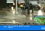
department of public work crews were here. they came out with shovels. they actually did a sweep of this intersection, swooping up any leaves that have fallen so far, so leaves aren't laying there. they don't watch into those storm drains and clog things up. talked briefly to one of the women doing the work. she says they're on 12-hour shifts. they're just basically driving around the city looking for leaves and things that are -- other debris, maybe trash, that might be in the area of a storm drain that could wash in there and cause it to clog. they're doing that work this morning. we've been talking to folks who live in this neighborhood. they're taking precautions. talked to one gentleman. he's raised up some things that are down in his basement. some of his neighbors have installed sump pumps and the like. this is what he said. >> this is a hurricane. it's going to be moving slow. it's going to dump a lot of
8:51 am

rain. we've had flooding with just regular storms. so i think a lot of people are going to be bailing water out. tomorrow, the next day. >> reporter: whether they get flooded, that remains to be seen. a lot of anxious people in the bloomingdale nabtd bauz they've seen flooding so many times before. reporting live, megan mcgrath, back to you in the studio. >> there were people who experienced major flooding. the city said it was going to do more to have sump pumps and better draining in that neighborhood. did any of that happen? >> reporter: i think there were a lot of things that were done with the incidents that happened recently. subsidies given to people so they could install these back flow valves down in their basements and the like that would prevent the water from the sewer system coming into their
8:52 am

basements. many took advantage of that program and did install those back flow valves. other people we've encountered here, on other stories on other days, they put in sump pumps. one guy put in three sump pumps in his basement. he's hoping that will take care of it. the city was out here over the weekend. there was a big effort to clear out all of the storm drains. they spent a lot of time doing that. we just saw another crew this morning. that's something they're continuing to do. the hope here is while there might not be a permanent fix, there's been a committee that has put together to try to figure out why suddenly they're having all this flooding in the area. while we're waiting for the results on that committee, there are some things being done short term to try and help people along and try and ease the flooding problem in this area. folks are hopeful, they've got their fingers crossed, some of these measures will help them this time around.
8:53 am

the problem is sandy is a huge storm and we've not even seen in this area the really heavy rain that we're expecting. we've seen moderate rain, but we've not seen the deluge we're expecting. so we're going to kind of have to wait for that to play out and see how the storm drains react and see how things go before we can know for sure. >> all right, megan mcgrath, live in the bloomingdale section of washington, d.c. who knows if those drains and sump pumps are going to be able to work fast enough, with the rain we're going to get. >> right. we are expecting rain in this area before this is all over. we're looking at what, 5, 6, plus, inches of rain. >> this is a multifaceted storm. i've got the latest up to date information for you. between the times you don't see me on tv, i'm checking all the latest conditions.
8:54 am
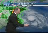
really, i'm changing how i'm looking at it because the forecast is all dependent on how sandy is tracking. it's going to have high winds, rainfall, flooding, coastal flooding, snowfall, and it is just -- huge storm. that's the other big thing about it. it is a very, very large storm. we look here at the latest couple of updates here on the satellite. we can see that the daylight is now beginning to show up on the clouds and these are clusters of very heavy rain way out here in the atlantic, rotating around the center of circulation, which is right here east of ocean city. it has taken the dreaded left hand turn i'm afraid. it does look like it's going to continue to track now farther to the west and past just north of the metro area is the latest track now. this just in. we'll keep you totally informed here as we do get through the rest of the morning. the zone of potential landfall has narrowed from central new
8:55 am
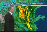
jersey down to just south of ocean city. so anytime, anywhere through here, it could be coming ashore. it doesn't really matter inside the zone because it's going to be affecting weather from england to the carolinas. moving inland as a fairly strong post tropical low. out ahead of that, here we are, 150 miles or so still away from the storm, we're getting these bands of heavy rain moving in from the east. also, some bands of snow. southern west virginia, southwestern virginia, getting snow right now. closer to the metro area. some of the heaviest rain so far just now beginning to move in to washington. those areas orange, those are the zones that have the pretty heavy rains. the areas where we see the oranges and reds, we're getting the heaviest rain. that includes western parts of the northern neck and aderondal county, they're getting heavy rain now.
8:56 am
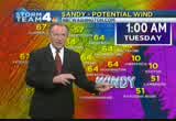
heavy rain into the evening hours. tuesday, this blue area may change over to a little wet snow. something bizarre to see some big fat wet snowflakes tomorrow morning. and then as we get into the evening hours, we could have wind gusts at near 70 miles an hour. that's about 6:00 p.m. until 3:00 tomorrow morning. i'm going to check on the latest and i'll be back in few minutes and we'll keep you informed with frequent updates. >> let's check in with the county executive for prince georges county. are you there, sir? >> i am here. >> nice to hear from you. thanks for joining us. what is the latest on the situation in prince georges county? how are your residents prepared this time around for this massive storm? >> we're actually in the command center. we've asked residents to go
8:57 am

online and make sure they sign up at princegeorgescountygoft.gov for "notify me" so they can get the updates of closings and information. we want to make sure the government of course is closed. our courts are closed. we're prepared for, best we can, for what's coming. >> we know last week you had your snowstorm dry run happened with your trucks and such. in terms of infrastructure for the county, are you prepared, or how prepared are you to deal with potential flooding or other types of damage that may be caused by this storm? >> certainly, we went and made sure first of all the county administration building which flooded during the 100 year flood, so we secured that, but here in the command center we not only have our -- every department head has a person here but we also have the
8:58 am

national guard from the governor's office. we have pepco and the other utilities here. so we can make an assessment all around as to what is needed in the county to make sure that folks are as safe as possible. one thing i do want to mention and our fire department asked me to do this is that people need to use flashlights and battery operated lighting equipment and not candles. because they can be dangerous. >> that's right, that is a good reminder. county executive for prince georges county. thanks so much for joining us. >> my pleasure, thank you. >> it is 8:58 now. you're watching extended coverage of hurricane sandy on news 4. live look on ocean city once again where the waves are crashing, winds are whipping up. the storm there is picking up. we could see more damage there. we understand one of the piers out there has been damaged already. we'll be right back with more coverage of hurricane sandy right here on nbc 4. stay with us.


9:01 am

it is 9:01 on this monday morning. thanks for joining us. >> we'll take a live look at ocean city, maryland.
9:02 am

the storm really picking up there. a lot of evacuations. people who have not left that area already have boarded up their businesses and homes and are trying to wait out this storm. the waves are getting really big out there. >> some of the other big headlines you need, all public school systems in d.c., maryland and virginia are closed this morning. the federal government is also closed to the public today. nonessential employees, you know what you're supposed to do when you don't have to report to your physical workplace, if you have some other physical workplace. also, most other governments don't completely shut down. closed in maryland, virginia and d.c. that's the first time they've done that since 2003. complete list of closings at
9:03 am

nbcwashington.com. >> we've been on the air for five hours now and we've seen live in front of us the conditions worsening. especially in beach towns. >> right there on the boardwalk we know things are getting rough and rougher as time goes by. >> they are. we want you to know, we just talked to the governor's office who tells us there is 400 people at shelters. two of them are taking pets. 400 people already have evacuated and have sought shelter at these areas. the mandatory evacuation was for anybody within three quarters of a mile at the beach or delaware bay. the winds are still comie ining. take a look at the fence here. because obviously the waters have breached the dunes and they're just coming undone. i think you've got some video of some of the fences drifting into the water. the storm surges have been absolutely impressive.
9:04 am
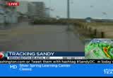
and they're still so much more to see. later tonight, after midnight, we're expecting storm surges anywhere from 8 to 11 feet. winds still gusting andhe rains coming down. just cuts across here. we've got a mouth full of sand while we're talking to you guys. most people have boarded up their homes and their doors that are located here. lee at the sand, the rocks that have come here on the boardwalk. if i can get my photographer to flip around this way. i want to show you what it's done so far. look at what it's done so far to the boardwalk. this is just all the way that's come in here. i mean, by later this afternoon, this is going to be a wreck. we talk about how big this is. i don't understand -- i don't
9:05 am

know if a lot of folks understand how big. this is possibly 450 miles, quite a distance between new york and d.c. this is double that now. 1,000 miles wide. when we say this is a freak of nature, really, i mean, this is mother nature like we've never seen her before. >> all right. we know the winds are whipping up. thanks so much for that. erika gonzalez. >> let' get a big picture look at what the storm is doing right now. >> those winds are right along the coast, gusting around 40 miles an hour. the center of circulation, look at this, very last update. watch as we look through the time frame. the latest satellite image showing it has made this turn to the west.
9:06 am
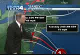
a lot of heavy rain. clusters of heavy rain farther to the east. that is going to wrap around and come inland. about 350 miles away from the storm center in washington and we're getting bands of heavy rain from it. the latest track is showing it coming ashore. the track has narrowed a lot. the potential landfall track is now really coming into much better focus. does look like it will come to shore anywhere between central new jersey and just south of ocean city. the storm is so huge. this does move inland as a post tropical storm area of low pressure. it will still have gusts of 60 miles per hour as it moves near our metro area. right now, the storm team for radar showing band, of moderate to heavy rain just east. as well as snow, getting some bands of snow. the storm is drawing in cold air from the midwest. there is a polar jet stream.
9:07 am
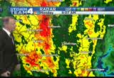
a lot of energy aloft at 25,000 feet. that's going to be getting ejected into the storm. it's going to increase the rain and wind as we get into the late afternoon hours. here's one band of heavy rain. prince georges county, in fact, just have now flood warnings from anaraldo and cabot counties. raining about an inch per hour rate. that is probably going to continue into the afternoon and early evening. they could easily get up to ten inches of rain there. the heaviest rains will end by dawn tomorrow. this whole area in blue, that's a zone of potential snow. we might get wet snowflakes flying through the air tomorrow morning. accumulating snow from central pennsylvania, to eastern west virginia, and that's going to continue through wednesday morning. peak wind gusts will start
9:08 am

kicking in around 6:00 p.m. by 8:00 p.m., gusts near 70 miles an hour. much of the region from eastern west virginia, northern shenandoah valley, northern virginia, the district, and much of maryland. those peak gusts are going to continue all the way till 11:00 and after, till 1:00 in the morning. over 60-mile-an-hour wind gusts will be common throughout the region. we'll have winds rise and fall. we'll have them get calm for a while. you'll have strong gusts coming through. some older limbs will snap off. some of the big old trees that are rotted on the inside, they could just topple over and unroot. the big story with rain is up to ten inches possible in much of northern virginia. flood watch out for the rest of the day today into tuesday.
9:09 am
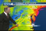
also, that blizzard warning, 6 to 12 inches of snow. near wide-out conditions with 60 mile an hour winds. this huge area under a blizzard warning. in addition, the high wind warning includes northern virginia, the district and all of maryland. that's for later today. that's going to be this evening. right now, gusts around 25 to 30 around the metro area. all the way up to long island. so hour by hour today, expect occasional bands of heavy rain. gusts to near 70 miles an hour. that will continue all the way till after midnight tonight. just a few passing showers tuesday into wednesday morning. finally drying out with some sun
9:10 am

back thursday, friday, saturday, and sunday. highs in the 50s each day. now, let's check on how this is impacting our traffic. here's din danella sealock. >> the earlier accident still block norbound lanes. they're still work to clear it. you can get by in the hov lanes. let's talk about some flooding in the district. if you're traveling southbound connecticut avenue this is the view at mccomb street. the 3100 block connecticut avenue seeing high standing water. you can see the right lane is blocked by the high standing water in this area. i would not recommend traveng right now. if you have the option to stay in, i would recommend you do so. >> danella, thank you. >> as the heavy rain comes into the area we're watching areas that could be affected by the rising potomac. >> some roads in alexandria are shut down in anticipation of the storm force. live from old town alexandria,
9:11 am

melissa, good morning. >> reporter: the river is high. we have not seen it flood up on to the area where i am this morning. there are other areas. prince street, some other streets, are getting iffy now. there are a couple of inches of water on these roads. of course only a couple of inches. that's all you need to lose your traction and slide. be careful if you're out and about. joining me is malcolm mccue. he has lived his entire life in old town and seen some pretty good rains down here. you came out with your brother this morning to check things out. what do you think? >> it's not that bad now. the city has a great team preparing for this storm so it should be okay. high tide, might do some flooding on strand and union street but i think it should be fine. >> you said you've been voting your entire life. think about other storms. what do you think was the worst and how do you think it will compare? >> isabelle was worse for old
9:12 am

town. bellevue, mount vernon had the most substantial flooding. i thk it will be more like that. >> how are you preparing? >> just common sense stuff. flashlight, batteries, cell phone charged, water that kind of stuff. >> it's picking up quite a bit as we're standing here. >> i do think the potomac's getting more angry. >> all right, malcolm, thanks so much. you have shorts on and i know you're saturated so i know you're check on some job sites. we'll be here throughout the morning. you can see the water getting a little more choppy. the wind pick up just a tad. we had this kind of steady rain just pounding down. live in old town, alexandria, megan mcgrath, back to you.
9:13 am
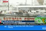
>> crews have to ride out the storm before jumping into action. our coverage continues with tony tull live at the montgomery county fairgrounds in gathersburg, the staging area for a lot of crews. >> it is the staging area. i got to tell you, it's impressive to see the mutual aid we're getting from alabama power companies, arkansas power companies, as well as north carolina. again, we're at the fair grounds. take a live look behind me. you can see the trucks lined up. they're actually getting some fuel. the crews are at hotels, getting some mandatory rest time now. a lot of them coming up from alabama, arkansas, as well as north carolina. one of the big things we've been talking about this morning is that wind. they're not going to be able to get out and make any repairs and make any assistance until sandy
9:14 am
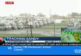
calms down. so if you do experience some power outages, just understand these guys have to work in semisafe conditions but they will be out there as soon as possible. pepco has contractors standing by. they said they started making the mutual assistance call about the beginning of last week. they said they were going to start expecting crews in this weekend. the fair ground, a massive, massive turnout. alabama, awell as north carolina. they sent in a tractor trailer with some satellite dishes. they'll be assisting at some locations. again, they're going to be
9:15 am

sitting around till sandy calms down. 3:55, which is a big thoroughfare. so we don't want you heading out this morning. then again, 3:55, you can make your way down that way. we're going to stand by and keep track of the crews. some of the crews actually came by shuttle and got some of their trucks. they're taking them back ton the hotel. making sure all the aprparatuse are working. so assisting pepco as they make service calls probably within the next two days. so these guys are going to have to wait this out along with everybody else until they can get those semisafe working
9:16 am

conditions. they will prepare and follow through with their service. back to you. >> sandy is to blame for this. look at this. a rude awakening in north carolina. strong wind gusts from hurricane sandy forced that massive tree to come down on to this family's home. this is in wilmington, north carolina. it happened yesterday morning. a mother and daughter were sleeping in a bedroom when that tree just completely crashed through the ceiling and, believe it or not, neither of them was hurt. >> incredible. especially looking at the size of that tree. check out this video. a man walk his dog nearly got a cold ocean dunking. run away quickly. we've seen the waves there getting bigger all morning long. that's just kind of dangerous. you know the waves are going to keep crashing. >> teach that dog to using a hitter box litter box when the
9:17 am
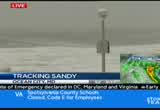
boardwalk is like this. this is a vantage point we've been able to show you. you see just how tremendous the waves are along the beach. ocean city, maryland. we know a lot of this water's been crashing on to the boardwalk all along the coast. >> part of the boardwalk pier has been badly damaged. we understand there have been evacuations. residents there who have boarded up their businesses. at the height of the storm, the storm continues to get violent, we don't know whether that will be enough. there will be some flooding, absolutely. i think that is unavoidable at this point. >> reaching 15, 20 feet in some cases. we know there are wind gusts in the neighborhood of 50-plus miles per hour at this point. again, this is just before the storm.
9:18 am

we still haven't reached the real crazy part of what really has been described as a monstrous storm coming our way. >> now, all the leaders in many jurisdictions have told people to stay off the roadways. we still have seen headlights this morning. danella sealock with the roads. >> taking the inner loop of the beltway at connecticut avenue, as you aproapproach, three righ lanes are being blocked. want to take you back to 395 northbound. still blocked as you try to head towards boundary channel drive. this is because the earlier multivehicle accident. you can see very windy out and very wet. aaron, eun, back over to you. >> we know there are some hurricane force wind warnings that have now gone up that cover parts of new york city. nbc's anne taumhompson is in
9:19 am

battery city, new york, anne. >> reporter: hi, i'm sorry, we're sort of running by the seat of our pants here. let me explain where i am. i am at the southern tip of lower manhattan. behind me, you can see the statue of liberty. that's ellis island here. this is where the hudson river runs into the atlantic ocean. this is new york harbor. you can see the swells in new york harbor, the white caps. they have been roaring for the past hour. it hit high tide here at 8:35. and now you can see what new york city officials feared. down here at the very lowest point of the promenade here, this is -- we are seeing water come over the promenade. this is the first breach that we have seen since this storm began. and that is what worries officials. it's why they've evacuated all the low-lying area, in new york city including battery park
9:20 am
city. about 375,000 people have been asked to leave their homes. now, it appears that most of them have. there are a few holdouts who said, look, during hurricane irene, you told us all to leave, it wasn't that bad, we're going to stick it out. mayor bloomberg has urged them to leech because what he fears is that they will get in trouble and when they get in trouble, they will call for help, and then they will endanger the first responders who come to help them. i can tell you that looking around battery park city this morning, we see very few lights in the skyscrapers. so that's a sign that people aren't home. also, we don't see a whole lot of people on the streets. matt transit has been shut down. the subway system which carries 4.3 million people in new york city alone. the entrances and exits down here are boarded up and fortified with sandbags. so there isn't a lot going on in the city. and that's good because the weather is so miserable. as city officials say, if you
9:21 am

don't have to go outside, just stay home. because it's only going to get worse. back to you. >> we were worried you might be swept away. you are so close to those swells. how windy is it? is it raining where you are? >> reporter: there are some pretty strong gusts. the rain has just started again. it comes and goes. we had 15 minutes of no rain, which was really pleasant. before that, we had two hours of rain. you can hear this very eerie sound. i don't know if you can hear it through my mic but i could certainly hear it. you can hear the wind whipping through the skyscrapers at the old world trade center site. it's just the wind whipping through those half built skyscrapers. >> anne thompson, thank you. if you're familiar with that region, hoboken, jersey city, both on the hudson river, they've evacuated.
9:22 am

canceled mass transit as well in new jersey. this is something that government officials at the very least are not taking lightly. they're making sure that people clear out as best they can. >> anne was showing us how the lower part of the water was lapping over the rail. it will only be a matter of time before she'll have water around her ankles. >> very true. let's look at, again, rehoboth beach, delaware. >> we know the waves are already reaching the dunes and have taken over the boardwalk at times this morning. good morning! wow. want to start the day with something heart healthy and delicious? you're a talking bee... honey nut cheerios has whole grain oats that can help lower cholesterol. and it tastes good?
9:23 am

sure does! right... ♪ wow. delicious, right? yeah. it's the honey, it makes it taste so... ♪ well, would you look at the time... what's the rush? be happy. be healthy. would ban all abortions and contraception seemed a bit extreme. so i looked into it. turns out, romney doesn't oppose contraception at all. in fact, he thinks abortion should be an option in cases of rape, incest, or to save a mother's life. this issue's important to me, but i'm more concerned about the debt our children will be left with. i voted for president obama last time, but we just can't afford four more years. [ romney ] i'm mitt romney and i approve this message. athat's what the plan georged allen supports... [ romney ] i'm mitt romney would cost our economy. newspapers called it "economically destructive." like allen's votes to give tax breaks to companies...
9:24 am

that ship jobs overseas, his economic plan would... help big corporations, devastating the middle class. allen even voted against tax breaks for small businesses. virginia can't afford to go back to george allen. the democratic senatorial campaign committee... is responsible for the content of this advertising.
9:25 am
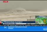
welcome back. live look outside at ocean city, maryland, where the waves are crashing and the winds are picking up guvts up to 60 miles per hour. that area and other beach towns will experience hurricane force winds later in the day. apparently the boardwalk pier has been damaged by the waves. we'll see much more damage and heavy flooding as well in parts of that area. >> let's go out west. these are live pictures from huntingt
9:26 am

huntington, west virginia. there was a great concern after some blizzard warnings were put into effect out there. upwards of two feet of snow pose nabil some parts of west virginia and virginia. you've got to have certain factors come into play. they're expecting to have some really treacherous conditions to deal with in eastern parts of tennessee as well. these -- we're being looking at three storm systems coming together to create this perfect storm, if you will. just a disaster for a lot of folks. >> so many different elements of the weather in one system, init's credible. people in washington are breaking out -- >> news 4 megan mcgrath is live
9:27 am
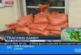
with more on preparations. good morning. >> good morning. i think a lot of people didn't go to work today. this is rhode island avenue. at this time of the day, this should be jam packed with cars. we're really seeing very light traffic. a lot of people are deciding to hunker down at home and watch it on their televisions. folks did do some things, took some precautions here. this is a neighborhood that's prone to flooding. they've pulled up the patio furniture just in case the water rises here along this unit block of rhode island avenue. we've been talking to folks all morning long who live in the area. what are you doing to prepare?
9:28 am

>> we packed up all the food we needed. >> are you concerned about flooding? >> yeah, i am. i know that they've done all they can to put the sandbags down. in the past, some of them have had water up to their ceilings, so it's definitely a concern. >> what about the wind? we're told it's coming. >> yeah, yeah, as far as power outages and stuff like that, in my experience in the past, it's taken awhile to get those things fixed. >> all right. good luck to you. i don't know if you can see this. see that person jogging? there's a shirtless man jogging wearing a horse mask. not quite sure what that's all about. but eun and aaron, i think
9:29 am

perhaps some people are getting a little stir crazy early in this -- i don't know where he came from but i guess there's an attitude with storms. you can either be scared and, you know, or you can have a sense of humor about it. i think he's got a sense of humor about it. obviously wanting some attention. i have to tell you, it's cold out here. i'm wearing all of this stuff and i'm so cold. this guy, shirtless, i don't even know what to say. >> i think he says mission accomplished. i just got on news 4. >> yes, thank you, his friends are at home going yeah. >> watch this, watch this. tweet us, we want to know who this person is. >> if he was really bold, he'd do an interview and talk about the whole preparation for that
9:30 am

antic. >> might be hard to talk through the horse mask. >> this was ed, who knows. >> oh, my goodness. all right, megan, thanks. see, this is what happens when people are stuck in their homes. there's no public transportation. we're just going to have some experiments. i have a feeling the horse man or the horse runner will not be the last interesting person, shall we say, interesting character. >> a little bit fun is okay now but it's going to get much more serious as the day progresses. >> danella. >> couple accidents. first the beltway. if you're traveling the inner loop of the beltway approaching connecticut avenue, three your right lanes are blocked. let's head to the outer loop. just after georgia avenue. as you're heading again toward connecticut avenue. another accident. this one just blocking the left side of the roadway. i am starting to see delays after you pass georgia avenue,
9:31 am
heavy bon the brakes. these lanes are still blocked as you make your way to boundary channel drive. you are forced off on to the hov lane to continue the trip northbound. this earlier crash involved four vehicles and is taking some time to clean up. back over to you. >> thank you very much. >> of course, we do want to get another look at how this storm is starting to increasingly impact our area. you're looking at storm team 4 radar right now. tom kieran's going to explain this. >> a lot rain where you see those areas in the yellows and oranges. this is a huge swath of rain coming in land. from the center of circulation right off your screen. we're going to zoom in on that. that center of circulation is about 350 miles from washington. it's way out there. in the very last update, the sunlight now is out. this is the visible satellite image. you can see the center of circulation. it has an eye right there.
9:32 am

moving at about 20 miles an hour. it has picked up speed. as it approaches the coast, it's going to slow down. these are all clusters of very heavy rain where you see these clouds all sort of bubbling up in the atmosphere. torrential lane from right around the center, as well as stretching further south and west there. other clusters of very heavy downpo downpours, that's just going to be all rotated inland. and bring it on shore through the evening hours. it will make impact anywhere from ocean city. the north part of it, the southern part of it, overall, huge area of rain and wind as it moves inland. could still be packing winds of 75 miles per hour by tuesday at 2:00 a. this is going to be its position by then. even up into pennsylvania, may still have some gusts by 2:00
9:33 am

p.m. tomorrow afternoon. the strongest gusts for us are going to be this evening, into the predawn hours on tuesday. right now, looking at the storm team 4 radar. this is the intensity scale. whenever you see it in the oranges and reds, that's where we have the heaviest rains. there's that snow. we just saw that picture from huntington, wefrt virginia. all this area of southern west virginia is getting heavy wet snow. look at that. it's still coming down there. that is a picture in from west virginia. you can post your pictures to weather@nbcwashington.com. we'll share them on twitter at facebook. that's weather@nbcwashington.com. the heavy rain bands continue to move into the washington area. right now, getting moderate to heavy rain. here's the intensity scale. right into the moderate to heavy zone. these areas in the orange zones from all across the district.
9:34 am
our eastern suburbs and prince georges county. stretching into eastern charles count. extreme southeastern county getting some heavy rain. howard county now getting some of this revy raheavy rain. the bands are not moving very fast, they're just creeping along and unloading a lot rain as they move along. already here on the western shores of the bay. under a flash flood warning there because they've already had two to three inches of rain there just this morning. it's going to be rains at maybe an inch or so an hour now for the rest of the afternoon off and on, all the way into the evening hours. there's a look at national airport. like megan said, it is cold. you don't want to be outside in this. northwesterly winds at about 18. the gusts there at reagan national, around 30 miles an hour. elsewhere, it's down into the chilly 40s. panhandle of west virginia into western maryland, shenandoah valley. only the upper 40s to near 50
9:35 am

degrees across most of maryland, virginia. the bay waters, it's in the 50s. here's the rain, time lapse, looking like we're going to have taper off and ending a lot of this rain by dawn tomorrow. maybe in the form of a little wet snow here even locally. i don't think we'll have any accumulation but maybe some big snowflakes early tomorrow morning. and then as we get into the daylight hours on tuesday, we'll have pretty much all the rain over. the peak winds are tonight, 8:00 p.m., peak winds to near 70 miles per hour all across northern virginia. most of maryland and the district. and between 8:00 p.m. and as late as 1:00, 2:00 in the morning, gusts over 65 miles per hour. that will do the wind damage. that will bring down some badges. with the soaked ground, some of the older weaker trees may topple over bringing down tree limbs. so the winds diminish
9:36 am
dramatically by tuesday afternoon. a lot of rain, 5 to 10 inches, may be causing some flooding. i'm back with another update. quickly for the rest the morning and into the afternoon. >> all right, let's check in with our reporter in long branch, new jersey. what are the conditions? >> reporter: we've been here for such a long time it feels like we got here at midnight and clearly it is quite the dramatic scene in long branch, new jersey, on the new jersey shore. really, the waves are spectacular so to speak. so forceful and when we came here at midnight, it was a wide-open beach. full of sand. nearly 100 yards till we hit the ocean. that is not the case right now. the waves have been coming up and hitting the boards here keeping up the boardwalk. as for the wind, we can barely stand up. also, it's become quite slick here on the ground due to the freezing rain. deaf hitly getting colder by the
9:37 am

minute as well. this is so interesting, the fact that people throughout this long branch community continue to come here. people started pouring in, taking pictures. we've asked many of these long branch natives why they aren't going inside. for some reason, they don't seem too concerned. this is not the top surge that's going to be coming here on the boardwalk. we're expect iing waves to come over. we have some stores that will definitely get hit and most likely flooded. so much drama, a lot force here. hurricane sandy in full effect in long branch. we're live in new jersey. back to you. >> if i can ask you, we know the buses were sent to atlantic city to evacuate people from there. are there any law enforcement there telling these folks they shouldn't be there? >> absolutely, great point.
9:38 am

every time a person comes up, which is nearly every couple of minutes, they blow their whistle so to speak and tell the people to leave and go home. for some reason, they just don't want to. we actually had to go to three hotels last night before finally getting a room. i spoke to a few people who were relaxing in the lobby and they said they live in long branch and they did evacuate their homes but they stayed in the town in order to not be too far and just basically get a hotel room. even though it's a state of emergency, even though it's an evacuation situation, these people are still sticking around for some reason. they have a lot of pride and they love their area here. but it's very dangerous and the police are trying their best. definitely, i just keep using the word dramatic because that's what these waves spell out. >> all right, thanks so much. >> now back to delaware. we saw some of the conditions starting to get rough there in long branch. this is erika gonzalez.
9:39 am

where it is much worse now. >> how you holding up, erica? >> reporter: hi, i was about to say that the waves were starting to decrease a little bit because high tide has passed. look at what it did to the barrier here, this bank. the waves are still coming in. we want to show you some video that we shot. this is what it looks like from up above. this is the second floor of the hotel we're staying in. you can see the waves crashing in. coming in on to the boardwalk here. you can see what it looks like from up above. down here below, just coiled up. there's chunks of wood all along the beach. and things like this are getting washed up. you see that? a couple of raking. i don't think anybody's going to be using that anytime soon.
9:40 am
the winds are not as bad as they were about an hour ago. they're still gusting at about 40. about 45 miles an hour now. the rain is still coming down. but it is very, very chilly out here. the storm surge you talked about are 79 feet. tonight, they're expecting to be anywhere from 8 to 11 feet. and this is something that people in rehoboth, for the older generations, we remember the storm of '62. for then, that's a storm -- there it is. the ash wednesday storm of '62. they said that was something they have trouble remembering. or they don't like to remember because of what it makes them feel. so they've decided to move on. the delaware governor is telling us they've got about 400
9:41 am

residents in shelters now. i'll step over this way. about 400 residents now in shelters. take a look at the boardwalk. you've got sand all over the place. look at the rocks. this is our hotel. you've got news crews all along the way. look at the sandbags. look at the way everything's boarded up. just a little while ago it was really the first time we saw the water just rush up and hit the bag. this is just a taste of what is to come later this afternoon. we could already be experiencing hurricane force winds. again, this freak of a storm as we've been calling it. 1,000 miles wide. it's just mass im. and cold because you're talking about two in one. a nor'easter and a hurricane together. eun, aaron. >> erika's making us nervous standing in front of those waves which look like they're about to
9:42 am
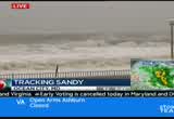
swallow her. later in the day, how much more powerful the wind and the rain. >> eventually, it's going to get to the point where it's not safe for our crews. and that is a warning for folks who might live along that area. the conditions are going to deteriorate. this is a live picture from ocean city, maryland. there are reports that the pier there in ocean city may have been destroyed at this point. >> that's right. the waves crashing there. we'll be right back with more on hurricane sandy right here on news 4. stay with us.


9:45 am

it is 9:45. we are tracking sandy as she works her way toward the eastern seaboard. >> that's right. we've been telling people to stay off the streets, it could be dangerous in these deteriorating conditions. there are people on the road causing some traffic problems. danella sealock now with the traffic. >> first, the beltway two separate accidents it the first one, the inner loop of the beltway approaching connecticut avenue it the accident here blocking the right side of the roadway involving an overturned
9:46 am

truck. now, the outer loop, approaching connecticut avenue, a separate accident. what it's doing is now blocking the left lane. you can get by but you're slow, squeeze into the right lane to get by the accident in this area. still keeping an eye on 395 northbound. all lanes still blocked as you make your way toward boundary channel drive. this is because of an earlier crash involving four vehicles. you can get by northbound in the hov lanes. please use caution. back over to you. >> thank you, danella. people here in the area are boarding up windows. >> especially where flooding tends to happen every time we get significant rainfall. news 4 megan mcgrath is live in the bloomingdale section of the district. looks like the rain has let up but still expecting significant flooding. >> reporter: absolutely. we haven't seen the really heavy stuff that we've seen in other areas. we've had anywhere from light rain to moderate rain. right now, it has eased up a
9:47 am

little bit. i will say the wind has kicked up a little bit. across the map, was kind of moving a little while ago and cause some issues there. we're still bracing for what we believe is the worst to come here. as you mentioned, people in this neighborhood know exactly what to do. they have scene so much flooding that they've got the drill down. you can see the sandbags in front of this business here. this is what everyone does here. the residents, the people at their homes, they all just go out, grab sandbags and then they hunker down waiting for the flooding to occur in this neighborhood. now, we're expecting extreme weather here with this storm of course. we're expecting very heavy rain. and they flood with just normal thunderstorm-type storms. so a lot of folks are a little worried. they're also very worried about the potential for very, very strong winds. this is a neighborhood with a lot of trees. if you look around here you can
9:48 am

see all the large mature trees that are here in this community. and some of them did not have the deepest roots. they're covered, surrounded by cement in many cases. people are kind of worried. when the wind kicks up, which we are expecting to happen in the next several hours, what will happen. >> i think the rain is going to be okay. everybody knows what they have to do. i think the wind is worrying the people. huge trees in my backyard, my neighbor's backyard. so that's what everybody's worried about, the wind. >> you can see that we do have some brave souls walking their dogs. getting wet in the process. it's a chilly morning, wet morn. we don't see -- the worst is yet to come here. so we're hunkered down, but the wind is starting to kick up here a little bit again. we are expecting it to get
9:49 am

breezier. >> you caused quite a commotion when you showed us horse man running through the streets of bloomingdale. >> reporter: no sightings of horseman. inwas hoping to bring you a dancing pig or something a little different this time around but not so. we got a person honking their horn, how about that. if we see him again, i'm going tory to snap a photo so we can -- >> there's more time, more time. >> all right, megan, thank you. as we've been talking, we're not the only ones who are bracing for hurricane sandy. >> in new jersey, the governor has declared a state ofening in and suspended all forms of transportation in the state. our report er er is there. >> reporter: the beach is almost hidden now because of the rising
9:50 am

tide. just crashing one wave after another. this is a completely different beach than we were looking at yesterday. there are flooding on several low lying roads. we had a photographer nearly stall out on one of those roads so it is no longer safe to drive around many parts of cape may where we are. a restaurant here known as the cove has been destroyed. this is early in the storm. this isn't even the worst of it and we're seeing this damage. we're also hearing reports of power outages that officials say could last up to two weeks. one important thing to mention is there are evacuation orders. many of those orders have not been followed. we have been seeing people walking around, trying to get a look at this storm. we've seen them patrolling. there's one right there, telling them to go inside because it is not safe and this storm is only going to get worse. those people that did not take the precautions, did not board
9:51 am

up, did not get the necessary food and supplies, they're going to be regretting that, as the storm progresses over the next hour. because this is not going to be short-lived. reporting live in cape may, new jersey, i'm danielle lee, back to you. >> we see long lines at grocery stores, the gas stations. people running out to get generators. there's no water in any of the grocery stores in this area for a while because of the mass exit -- mass run to the grocery stores right before sandy. >> let's see how sandy is progressing. developing right now. storm team 4 meteorologist tom kieran is here. >> there has been a dramatic change. when i came on at 2:00 this morning, sandy was still traveling to the north and east. but it has taken that turn more to the north and west in the last two or three hours. as we take a look, a lot rain inland. zooming in on the center of circulation, sandy has winds
9:52 am
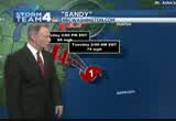
right around the center of circulation, about 85 miles an hour. it also is kicking up seas. around 40 feet near the center of circulation. around the atlantic seaboard, the seas are generally around 25 to 30 feet. about 20 miles or so off the coast. there are clusters of really heavy downpours around the center of circulation. that is ways going to increase our chances getting some flooding rain later today. the latest track does continue to show it's going to be coming inland from the central jersey coast, south of ocean city. this track zone has been narrowing. of course, get a much better view of when it's coming to shore. it will be a profit tropical area of low pressure at that point. it does look like it's going to be coming to shore around 8:00 p.m. this evening somewhere along the coast between central jersey down and as it drifts
9:53 am
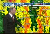
inland, it's packing pretty good winds. up to 60 mile an hour winds or perhaps more. we're getting a combination of precipitation. rain around the metro area. snow in west virginia and southwestern virginia. they're getting some wet snow now. it's already covered the ground there. it's only going to increase in the mountains as we get into the evening hours. radar showing us moderate rain. these bands here in the orange, moderate rain. when you get into the red, that's where it's coming down really hard. we've got one little pocket of that here in east central -- looks like charles county just to the east of la plata. heavy rain over central bay, just to the west of cambridge. farther west, light to moderate rain around northern virginia. that is a chilly rain too.
9:54 am
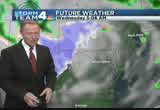
around the bay, it's in the mid-50s. out in the mountain, turning colder there, as the colder air will get wrapped into the storm it these areas in orange and yellow, that's the moderate to heavy rain. tomorrow morning, and then during the day, that rain is going to be decreasing and the wind will be increasing. the strong et winds are going to be coming in perhaps around 6:00. that is enough to break off some of those weaker tree limbs. with the ground getting saturated from the rain, that could topple trees. as we get into the later evening hours, still gusting. all the way till 1:00, 2:00 in the morning.
9:55 am
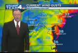
very strong winds will cause tree damage and pouwer outages. then the winds will decrease and we'll have improving conditions. wind gusts right now right along the coast, look at philadelphia, they just had a gust of 43. it is going to continue to drift those heavier areas of strong winds to the west. we'll have wind gusts increasing. just add that at reagan national. i'm back with updates all morning long. stay tuned. >> we have been tracking some problems on the roads as well this morning. not a lot of people who are going to work right now. now, your traffic. >> still following breaking news on the roads. two separate accidents slowing the beltway down. first, the outer loop of the beltway. at connecticut avenue, you'll see the right lanes blocked by the crash there.
9:56 am

the inner loop, overturned tractor trailer also causing big delays. this is a look at i-270. you're jammed as you get closer to the accident. you'll have to get to the left lane. but you're slow. still checking on the situation on 395 northbound, those lanes still blocked because of the earlier accident. again, you can get by. just in the hov lanes. back to you. >> thank you. >> it is 9:56. we of course will be staying with you throughout the duration of this storm. we're going to be here to provide information on air and of course online at nbcwashington.com. >> we'll also have a live press conference from maryland governor o'malley who will bring us up to date on the storm situationness state, especially in ocean city, maryland where there has been severe daniel to one of the board walk piers there as the wind and waves pick up. >> some live images as she comes
9:57 am

near shore. [ earnest ] out of the blue one day, we were told to build a 30-foot stage. gathered the guys and we built that 30-foot stage, not knowing what it was for. just days later, all three shifts were told to assemble in the warehouse. a group of people walked out on that stage and told us that the plant is now closed and all of you are fired... i looked both ways, i looked at the crowd, and...we all just lost our jobs. we don't have an income. mitt romney made over 100 million dollars by shutting down our plant and devastated our lives.
9:58 am

turns out that when we built that stage, it was like building my own coffin, and it just made me sick. [ male announcer ] priorities usa action is responsible for the content of this advertising. what mitt romney's tv ads say prioabout women?ction or what mitt romney himself says? mitt romney: do i believe the supreme court... should overturn roe v. wade? yes. and it would be my preference that they, that they...
9:59 am

reverse roe v. wade. hopefully reverse roe v. wade. overturn roe v. wade. planned parenthood, we're going to get rid of that. i'll cut off funding to planned parenthood. anncr: no matter what mitt romney's ads say. we know what he'll do. president obama: i'm barack obama and... i approve this message. you are watching continuing coverage of hurricane sandy
10:00 am
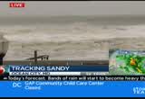
right here on news 4. welcome back. good morning to you. >> it is 10:00 right now. as we take a live look at some images from ocean city, maryland, this morning, we can tell you that the surf has obviously come in. the tide has come in. that happened a couple hours ago actually. we still see significant wave action. this has actually -- just a little while ago. still incredible waves. >> causing damage as well. police say the boardwalk here and there, part of it has been badly damaged. we're going to see more damage, more winds whipping up as this storm continues. and the weather conditions continue ton deteriorate. >> we're awaiting a press conference. the governor of maryland will speak very shortly about what they're dealing with in maryland. that's happening any moment. we'll bring it to you live as
10:01 am

soon as it happens. >> first, the latest on the track. >> those are dramatic pictures. there's a lot beach erosion going on. all along the atlantic beaches from chincoteague. they now have the rain taper off a little bit. the heaviest rain is inland. heavier rains around washington and southern and eastern suburbs. we've got snow falling in southern west virginia and southwestern virginia. it has covered the ground in many low i ka, there. some of the more moderate rain you're moving in these areas of arrange. right now, getting some moderate rain in the district columbia. that stretches to southwestern prince georges county. that one band into the northern neck of virginia. there's another band about to move in. it's now coming in from the
10:02 am
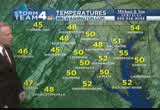
eastern shore. just crossing the bay, about to move into adorondale county where they've got flood warnings out. three, four inches of rain falling on the eastern shore and western shores of the bay. farther to the west about an inch or two has fallen. and as we look at temperatures, it's right around 50 degrees, around much of the region. so it is a chilly rain that's coming down. in fact, even colder farther to our west. shenandoah valley, blue ridge. it's in the mid-40s now. it is sort of a hybrid storm because it has snow and it's got tropical downpours associated with it. going forward, here's the future river. by 5:00 p.m., we'll have bands of moderate to heavy rain. it's after that that we'll get the strong winds. then by dawn tuesday, that's the area of potential snow. we might get some wet snow locally. there will be snow falling,
10:03 am
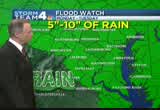
western maryland, across eastern, west virginia. that's going to continue all the way into wednesday. it should taper off wednesday night. a blizzard warning out. garrett county, western maryland. all these counties, eastern, wefrt virginia. 6 to 12 inches of wind driven snow. winds could gust to 60 miles an hour. talking abo ing abouing about w conditions. they've got some high water developing. they've got flood warnings out. and elsewhere, flood watch out. all these counties in green. and much of the rest of maryland for 5 to 10 inches of rain by the time the bulk of the rain ends by midday tomorrow. but the biggest story is going to be the wind. gusts to 70 miles an hour.
10:04 am
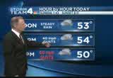
all these counties under a high wind warning for the rest of the day today and into tuesday. this is where we could get the wind damage. the winds are picking up. ev woo had gusts around 40 miles an hour. ocean city had a gust of 43. reagan national had a gust of 36 miles an hour. elsewhere farther west the gusts are lighter, 20 to 25 miles per hour. they're going to be increasing. ocean city just had a gust of 43. as we look hour by hour, the winds will still be gusting up to around 30 miles per hour. bands of rain coming through. temperatures just in the chilly, low 50s. then the gusts will be even higher. occasional gusts between 6:00 p.m., all the way until after midnight tonight. may reach 70 miles an hour. it's not constant wind. this is just occasional gusts.
10:05 am

up to 70 overnight tonight. storm team 4 four-day forecast. showing chilly temperatures tomorrow. a few wet snowflakes in the morning. maybe a lingering shower wednesday morning. drying out after that. thursday, friday, saturday and sunday. we'll get some sunshine back and dealing with the cleanup and recovery and long-term, unfortunately, power outages. we'll be dealing with that probably for sever more days. back to you. >> all right, thank you, tom. >> we're waiting a news conference by governor o'malley. >> a couple of places with power out across the region. we can expect the numbers to grow significantly in the next 24 hours or so. >> we'll bring that news conference to you live. >> erika gonzalez has been braving the elements there for us.
10:06 am
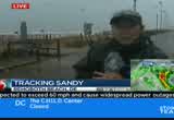
erika. all right. it looks like we may have trouble with erika's signal. she's been on the beach -- all right, there we go. >> can you guys hear me? our mic's cutting in and out. obviously, things are getting in and out. things are getting worse. water keeps coming in. >> all right, well, we're having some trouble with erika's mic as the weather deteriorates. some very strong winds, getting stronger still.
10:07 am

i don't know how much longer it's going to hold as the storm continues to pick up power. >> we know erica talked about sustained winds where she is. at this time, roughly in the 20 mile an hour. there have been gusts up to 50 miles an hour there. hundreds of thousands of people could lose power in the coming days. >> bringing in hundreds linemen from across the country to help restore power. we are life at the fairgrounds, the staging area for the utility company. good morning to you. have you seen any action yet? >> these guys are not going to come out. probably not today. they'll probably come out tomorrow, or even wednesday. as you guys have been saying, the high winds are going to be dangerous conditions for these crews to get out and make repairs.
10:08 am

so not a lot going on at the fairground. i can tell you there has been a massive turnout for the requests pepco put out last week. take a live look right now at the fairgrounds. you can see numerous trucks from around the region who answered that mutual assist call. bringing generators, bringing commercial-sized lights. everything they can to assist pepco when they start answering service calls later on in the week. these guys are at their hotel. mandatory rest. they were driving in all this weekend. some were in this morn. you're not going to see any action out of these guys probably until sandy calms down a little bit. now, we don't have a shirtless horseman but i did run into a couple walking from the hotel. give me your names real quick. >> anthony. >> cathy. >> where you from? >> florida. >> what are you doing out?
10:09 am

>> we're used to hurricanes. we've learned over the years if you don't get nailed by the center of the storm, the fringes don't really bother us too much. we were affected by charlie, by andrew. to us, it's no big deal. >> what are you headed? >> just up to the strip stores to see if anybody's there. >> killing time. >> because we'll be stuck once it really turns bad. >> did you guys drive up or fly in? >> we're in for a wedding. >> that can be troublesome for you there. thanks. good luck in the storm. interesting to see some folks walking out. it is very chilly outside in the last -- i'd probably say half hour to an hour here in gathersburg. temperatures dropped considerably. we've picked up rainfall from the drizzle. conditions are worse being. surprising to see them. pepco has over 400 contractors on standby. they also have hundreds of crews from alabama, arkansas, as well as north carolina. again, guys, if you do experience some of the power
10:10 am

outages, give these guys time to get out. they need to work in somewhat safe conditions as they're working around these power lines and putting the booms up. we'll continue to stay here, see if we can get in touch with any these guys. as of rig now, the plan is a little bit of mandatory rest. and then wait out the high winds and see what sandy brings to us. we're live, tony tull, news 4. >> that couple from florida whose flight was canceled, they're hanging around. apparently at some of these rental, car rental companies, people are trying to rent cars now to try to drive back, because they were in town for the marathon or for whatever reason. they can't get a flight. they know they won't be able to get a flight for next few days. try to rent a car, get out of here before the weather gets bad. they have to do it soon at this point. >> or find a hotel. they know they're going to be stuck. at the end of the day, stay in play keep safe in one spot. all right.
10:11 am

we've been looking at some issues on the road. >> i would recommend, if you are taking the beltway, just remember the inner loop of the beltway. as you approach connecticut avenue, i'll show you some delays. i-270, you can see these cars are just sitting. back to you. >> thank you. want to go to maryland. governor o'malley is giving a brief on the latest on hurricane sandy. >> let's listen in. >> -- command center, and i have with me ken, our director of maryland emergency management agency, and also lieutenant governor anthony brown is here, as are various commanders of all of the people who are working to
10:12 am

keep us safe in this big event. look, i think what most of us have figured out that most of us are in the cross hairs. hurricane sandy is increasing in intensity. it will go across maryland, from garrett to the eastern shore and the atlantic. we're also seeing effects of it in ocean city. in the baltimore washington corridor, we anticipate high winds by the early afternoon. we're anticipating having to close the bay bridge once the winds reach a certain intensity and speed.
10:13 am

unlike the intensity of the previous storm, hurricane sandy will come over maryland, will sit on top of maryland and beat down on maryland for a good 24 to 36 hours. there will be many trees that go down. there will be many power lines that go down. there will be many families who are without power and those power outages should start happening this afternoon and this evening. while we have brought in and had pushed pepco to bring in outside crews, they have, in fact, done so. many outside crews have predeployed at staging areas. those crews can't go up in those bucket truck, at 60 mile an hour winds so this is going to be a long hall. the days ahead are going to be difficult. there will be people who die and are killed in this storm. we are ordering at urging all marylanders to stay off the roads for the next 36 hours.
10:14 am

these are very dangerous conditions. we ask you not to put yourselves or your family in jeopardy and not to put our first respond er in jeopardy by irresponsibly staying out on the road. these next 24 to 36 hours are going to be time when all of us need to hunker down and shelter in place. speaking of shelters, there are 23 open in our state. you cab find the locations by going online. however, these shelters are open to accommodate people who are going to likely be displaced from their homes. so we're not urging people necessarily to run for the shelters by any means. they're open in anticipation of those who may be forced out of their home by falling trees and the other wind conditions. so right now, the order of the day is this -- stay off the
10:15 am

roads, hunker down at home with your families. it's going to be a long 24 to 36 hours. the shift in the storm means a couple of things. one, that we will be hit with the most intense winds of the storm. two, those -- that potential title surge which we had thought would be minor will be actually causing a lot of flooding in the streets and in the rivers of the chesapeake bay. why is that? because as the wind shifts, it will no longer push the water out of the bay, it will push water up into the bay, and that combined with the rain, we'll see tripbutaries overflow in was we haven't seen since hurricane agnes. so one of the things i have an update on, no announcement yet in terms of early voting tomorrow. we'll update you in a few hours
10:16 am

on that. questions? [ inaudible ] ocean city is being lashed by a combination winds and rain and also very, very heavy surf. from looking at the charts, talking with the mayor of ocean city, lower ocean city to downtown, where there is a mandatory evacuation, is inundated. there's water covering all of the streets there. i understand their pier has suffered some intense damage. i think we heard that pier down in ocean city have gone. so looking also at the cameras, the draw bridge, you can see the inundation from that as well. evacuation has gone smoothly. certainly the evacuation has gone very well.
10:17 am

the tidal surge on the bay is pretty intense. michael. [ inaudible ] my biggest concern right now is the potential for loss of life. as these winds bring down trees and cause a lot of hazards on the roadways. my biggest concern is trying to get out that mess am to people, that they need to be indoors for the next 24 to 36 hours. this will be unlike any storm we've had to weather. it's going to be very intense. it's going to be very violent winds. the safest place for you to be is indoors. [ inaudible ] i feel that the coordination, the communication, is very title and very strong. the weather forecast has turned
10:18 am

for the worst. so the reality for maryland is worst than we had thought it might be. having said that, we prepared for this turn. we saw this storm wobbling. we knew that the storms can only shift and change. our job is to adjust and to be prepared. so we are prepared for the worst. we have deployed a number of federal assets that have been with us. we also have national guard forces that are predeployed all over the state. i just concluded a conference call with all the county executives and a number of the mayors from all 24 jurisdictions in our state. as i said, the towns and cities. so the commune conversation is good. that's some of the most important things you can do. the other thing that has happened is the advance warning of the storm allowed pepco to start bringing, druing in assets from other states, so they're
10:19 am

predeployed in ways that they weren't before the -- and we hope that even more assets will start moving their way north as the southern states emerge from the potential they had for emergency. [ inaudible ] well, i'm concerned about all of them. american weather disaster. we have blizzard conditions in garrett county. high surf in ocean city. we have tidal flooding all up and down the bay. so all of these things are happening all at once across our state.
10:20 am

flooding is likely to be an emergency for several days. that's going to put a lot of stress on the tributaries that flow into the susquehanna. will create that deadly dust on some of the critters that live on the bay grasses, along the bottom. [ inaudible ] yeah, the -- look, we had some people die in the -- this storm is more intense. my intent, truthfully, identifying this as a killer
10:21 am

storm, to make sure every family has the information they need so they can act responsibly and stay indoors. the most important first responders are the moms and dads of maryland who keep their families indoors and their spouses off the roads for these next 24 to 36 hours. that's what we all need to do. we need to watch out for each other. the intensity of this storm is such that there will undoubtedly be some deaths that are caused by the intensity of this storm, by the floods, by the tidal surge and by the waves. the more responsibly citizens act, the fewer people will die. okay, thank you very much, appreciate it. >> we've been listening to governor o'malley. the governor used words like violent and intense in
10:22 am
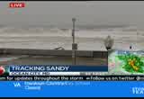
describing sandy. he said unline the previous storm which came through and left quickly, sandy will sit on top of maryland, beat down on the state for 24 to 36 hours. >> very matter of factually saying he fully expects that people will die as a result of this storm that we now know is at least 1,000 miles, and one that has winds that are intensifying as we speak. 85 mile per hour winds. some of the hurricane hunter reports have tracked winds at 90-plus miles an hour. this is something no one is laughing at, they are taking it very serious. >> the first responders, the people who are the residents of the neighborhoods who listen to the warnings, stay off the street, keep your kids, keep
10:23 am
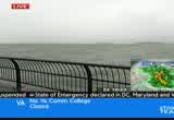
your pelt pets indoors. the more responsible citizens are, the fewer deaths there will be. >> ocean city maryland, the surf is intensifying. the governor says. we also know virginia governor bob mcdonnell will have a press conference early in the afternoon. we'll have much more coverage here in just a moment. [ minto ] you know, those ads saying mitt romney

10:25 am

would ban all abortions and contraception seemed a bit extreme. so i looked into it. turns out, romney doesn't oppose contraception at all. in fact, he thinks abortion should be an option in cases of rape, incest, or to save a mother's life. this issue's important to me, but i'm more concerned about the debt our children will be left with.
10:26 am
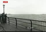
i voted for president obama last time, but we just can't afford four more years. [ romney ] i'm mitt romney and i approve this message. at 10:26, you're looking live now at battery park city, new york. this is one of the lowest points in lower manhattan. the water is up and over the seawall at some points. this is just the beginning for what they're going to experience in parts lower manhattan. >> the swells are growing there as well. we expect water to continue to move on top of the promenade. tom kieran has been tracking sandy and is going to tell us about the intensity. >> sandy is still a category 1 hurricane. winds around 85 miles per hour
10:27 am
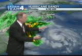
around the center. the winds go way out. we're going to have a tropical storm force wind moving in during the afternoon and then near hurricane force winds as it moves inland. it is pushing heavy rain inland all the way into our region, delaware, maryland, into virginia and up into pennsylvania as well. and it's going to continue to move our way. over the last several hours, it's taken that dreaded left-hand turn we've been advertising. it has indeed turned to the west. it's been moving at about 20 miles an hour. it will move more to the northeast. here's a close-up view of the center of circulation. really a lot of rain around the center here. the buoy off the atlantic seaboard. right here is the atlantic seaboa seaboard. there's a buoy. reporting waves of about 25 feet. water temperatures there are in the mid-60s.
10:28 am
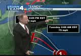
they're a bit warmer out here. it has taken that turn to the west. it is going to begin to head inland. the latest track which is going to be updated here in about a half an hour. i don't think it's going to change very much from this one issued at 8:00 this morning. it does look like it's going to be coming inland from the val jersey coast. in this zone, it puts the center of circulation coming in. it has a very wide effect of wind and rain so as it does come ashore, it's going to increase the wind and rain from boston, all the way down to the carolinas. as it does move inland, it's still going to be packing some powerful winds. there's going to be a jet stream that's going to get ejected into it this evening. that's going to get it a little surge of energy. that will spin up and give it some more wind as well as squeeze out some more rain from it. 350 miles away from the center
10:29 am

of circulation. and there's been enough cold air for it to produce snow out here in southern west virginia. snow is covering the ground there. down to just about west of ro wh roanoke, they're getting okay? . southern prince georges county, saint mary's, they're getting pockets of heavy rain. look at this dark gray sky. visibility dropping now at national airport. live view from our nbc 4 camera. 52 at regular be national. theme got a steady wind there at about 25 miles per hour. a peak of 36 this morning but it's going to increase. it is a chilly rain. it'sed on around 50 degrees.
10:30 am
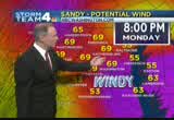
shenandoah valley is only in the mid-40s now. it's going to turn colder there as that cold air does get wrapped into the system. as we go forward, here's the future weather, all this area in yellow and orange, that's moving through into the afternoon hours. snow really picking up in intensity. might even get a few snowflakes here tomorrow morning as the rain tapers off and comes to an end by tomorrow afternoon. the wind will be over but we're still dealing with wind. wind gusts at 70 miles per hour beginning at 6:00 this evening. and then by around 11:00, we'll still have heat gusts in the 60s throughout much of the region. as we get into midnight, we'll still have gusts around 60 miles an hour. then the gusts will increase as we get into tuesday afterman and tuesday evening. the winds will be down to about 20 miles an hour. right now, gusts are near 40 from philadelphia to ocean city down to virginia beach. reagan national, gusts at 36.
10:31 am

gusts locally, generally much of the region is in the 20s. near the bay waters, just had a gust of 38. we'll have bands rain off and on. by none time, in the low 50s. maybe low 50s during the afternoon. much of the region near 50. gusts come in 6:00 tonight. we'll have those high gusts till after midnight tonight. perhaps near 70 miles an hour. that would be all the way until after midnight tonight. that would cause the tree damage, all the power outages. we're probably going to have widespread power outages. as we do get into tomorrow and wednesday, it tapered off. we get some sunshine back. that is the way it looks. we'll be back here with storm team 4 coverage in another few minutes. >> thank you, tom. as of 9:00, we'll no longer have
10:32 am

any flights going in and out. >> dulles and reagan had significantly reduced the number of flights they were expecting to have today, into this evening. some 8,000 flights canceled. 8,000-plus flights canceled as a result of hurricane sandy and what is anticipated. >> the problem is, with so many flight cancellations, it may be weeks before these flights are rebooked so a lot of people will have to wait it out. >> let's see how things are looking. we've had some problems. how's it looking? >> seeing problems along the beltway. this is an accident involving a tractor trailer. blocking lanes as you get closer to connecticut avenue. very slow trip from i-270. three of your right lanes are blocked. i have some good news. 375 northbound, earlier, all the northbound lanes are blocked
10:33 am

because of the accident there. now those troughle lanes are open and as far as accides,nt you're clear in this area. back over to you. >> thank you. >> people in d.c. are breaking out the stand bags and boarding up windows. >> that's especially the case in some flood prone neighborhoods. megan mcgrath is live in the district. we've been watch the rain get heavier and lighter. folks who live here are worried. >> yeah, they're nervous. they've seen flooding here before with just average storms. this is a whopper of a storm here. we're expecting some torrential downpours. we have seen the wind pick up in the last hour or so. this is one of those really tough spots for folks who live in the area. there's a couple of hills that come down here. lead to this area. when the storm drains back up in the rain, this spot just absolutely floods and floods
10:34 am

very quickly without a whole lot of warning for people who live here. a lot of people who live in this general area have had water in their basement several times. they're very, very worried about what's going on here with sandy. we've had businesses who have had sandbags in front of their doors. just a few moments ago, they did come here. removed the sand bags. they're going to try to open for business as long as they can here. of course all of that depends on what the weather does. they're keeping an eye on it. keeping an eye on the roadway to make sure there is no flooding. it is a real possibility in this neighborhood. a lot of people are worried about it. ann is out here, out and about this morning. you say they normally don't take storms seriously. this time, it's a little different. >> it is a little different. i've never lost power but i'm prepared this time. i actually have the flashlights all around. i filled my bathtub with water which i've never done before. actually bought water. i locked up my garbage can and
10:35 am

recycling bins because those can get pretty dangerous. brought in the pumpkins of course. >> you've been walking around this morning. are you seeing a lot sandbags? seeing people doing things to prepare? >> i am. there's also great neighborhood places. a lot of these restaurants say they'll be open. >> are you going to hunker down at home? >> that's why i'm out now. it probably won't be safe. maybe wait for pat collins to show up in the neighborhood. >> thankses for joining us. that is something to keep in mind. we heard the governor talking about how dangerous this storm is. he believes people will die in this storm. that's how big it is. we're not necessarily seeing the full impact right here, it is
10:36 am

coming. people need to keep that in mind. later this evening through the night, it's going to be a different story here. we're seeing moderate rain now. but it is nothing compared to what we're expecting later on in the overnight hours. when things can really start going. power outages, power poles coming down. so play it safe, hurnger down, go, gather with friends, ride the storm out.nker down, go, gather with friends, ride the storm out. >> we noticed the traffic behind you. so many people seem to be out. are there stores open where you are? >> we're starting to see
10:37 am

activity. windows cafe is the first business we've seen open in this general area. they opened literally i'd say five minutes ago. across the street, there's a liquor store. there's a restaurant down the way here. those are not yet open. there's a cafe about a block down. ann just referenced it. that has been open all morning long we're told from people passing by. so it's kind of hit or miss. even if they open, it doesn't mean they'll stay open through the day. the dry-cleaner across the street, they've been open since the wee hours of this morning. we have seen -- it started out as a ghost town.
10:38 am

we're seeing a lot of people out and about. >> megan mcgrath, thank you. >> that is the theory here for a lot of people, residents want ton get out early before they know they won't be able to get out of their homes. at least something for people to do. >> here in the district, it's going to get ugly. >> we've seen the most dramatic images, where our erika gonzalez has been all morning long. how's it looking now? >> we tried to talk earlier and the mic was cutting in and out. nearly five inches of rain thus far. the winds are kicking up.
10:39 am
there you go. you getting all of that? that's the wind. okay. let's go -- i want to show you this. this is what the water has done. check out the erosion. this is about to give way. i want you to take a look at the southern side over here to the right. this is just so amazing. this has been able to do within the last two hours. the storm surge is still -- meteorologists saying by midnight, we could see 8 to 11 feet storm surges. we have heard people say we think they're going to be okay. you couldn't be more wrong. it's 1,000 miles in width. although we may not take a direct hit, much of the eastern coastline will see huge effects because of this storm. come around this way.
10:40 am
take a look at some of the stand and rocks. i'll tiptoe around this way. take a look at this. look at the waves coming in. this is mother nature at her finest and so much more to come in the next few hours. later this afternoon, we could experience hurricane force winds. 400 people here in rehoboth have already sought shelter. can you guys still hear me? we've got an interview with a member of the red cross. they were telling us some information.
10:41 am
>> i think they're taking this storm seriously. they're bringing their medications. they're planning to be there a while. they're bringing their pets with them. they're ready to be there for a while. >> yeah, that's definitely going to be the case. so pack your patience. this is going to be a slow moving storm. it is going to take some time for all of us. the waves just bombarding the beach. a very windy, very cold beach day. >> all right, erika, live for us. erika, thanks so much. >> we are seeing some rain here in northwest d.c.
10:42 am

>> yes, since i've been out here in the last 15 minutes, the rain has intensified. it is getting windier. i've listened to you guys doing great coverage today. all of our reporters and our colleagues doing great coverage. we just heard from maryland governor o'malley. he's told us, take the proper precautions. that's something we all need to do. i can speak from personal experience coming that work today, the roads were completely empty come down wisconsin avenue. people are heeding those words of advice and taking the proper precaution. one thing i want to say to everyone, we covered this, this is our job, but let's not forget, this is a human being story. if you do nothing else today, reach out to those you love.
10:43 am

let's not always focus on twitter and facebook but make that phone call because when the governor says people will die in this storm, realize this could be life or death. live on the weather desk. keith russell news 4. >> we're going to toss to a break right now. first, ocean city maryland, where again the waves are crashing out there. looks like there's someone on the beach maybe enjoying the pictures. trying to document this tremendous storm.


10:47 am
now, parts of lower manhattan, where the seawall there has already been topped by waves. you're looking at one of the ships there that is sort of out into the water, if you will. we know oftentimes, those ships are safer being away from the shore. >> we know the holland tunnel and brooklyn tunnel will close at 2:00 p.m. this afternoon. holland tunnel, brooklyn battery tunnel. jurisdictions up and down the east coast not taking any chances, making sure they are ready and don't cause any more problems by having these thoroughfares open for people who might be trying to drive. >> there are reports about significant street flooding in parts of the bronx and queens as well. the subway system shut down in subway city because of the concern about water coming down into the subways as well. >> tom kieran now with the latest. >> sandy has taken that left
10:48 am
turn, and is now tracking off to the north-northwest, moving at 20 miles an hour. look at the radar showing massive amounts of rain coming in. a huge area of rain from massachusetts all the way down to north carolina. and from just off the coast, all the way inland, into the ohio valley, and it even mixes with cold air and produces some snow out in west virginia. here is a close upview of the center of circulation, which is now about 300 miles from washington. it's tracking off to the north-northwest, right around the center of circulation. winds about 35 miles an hour. the latest track, which will be updated in about 15 minutes, but probably not going to change much from this track at 8:00 a.m. coming to shore from the central jersey coast, to just south of ocean city. the center of circulation coming to shore in here. but the effects of the wind field are so wide, it's really not going to matter too much where it comes in, in this zone. inland, it does look like it's
10:49 am
passing perhaps just north of washington. as we get into late this evening and early tuesday morning. still packing quite a purnch. packing wind and rain. right now, moderate rain. these areas in the orange and red, it's raining hard. right now, around the metro area and to our south and to our north, with that one rain band. this a persistent area of some snow. snow covering the ground, southern west virginia, southwestern virginia. here's a close-up view of the radar showing bands of moderate to heavy tropical showers moving in east to west and drifting off to the west. right now, raining pretty hard, right around the beltway, inside the beltway, up and down from the maryland border with pennsylvania, all the way down to the northern neck of west virginia. you can see visibility has dropped there. chilly 52 degrees. northwest winds at about 24 miles an hour. but the gusts have been over 35 miles an hour at reagan national. temperatures around the region are chilly.
10:50 am
around 50 in the maryland area. in the mid-40s, shenandoah valley, the mountains of western maryland and west virginia. as we take a look going forward over the next 36 hours, looks like the heaviest rains coming in during the evening hours, that will pass off to our north and west. will really weaken. a lot of the rain will dissipate by tuesday morning. maybe a few wet snowflakes off in the shenandoah valley to our west and north. it does look like a persistent area of heavy wet snow and strong winds out of the mountain that may linger all the way into wednesday is the way it looks now. peak winds for us should kick in around 6:00 p.m. we could have them gusting as high as 70 miles an hour much of the region. this is at 8:00 p.m. still gusts over 60 miles an hour. that's when we'll have the bulk of our tree damage and our power outages happening. this may continue to gust till 1:00 in the morning. the winds begin to diminish. it could be over 50 miles an
10:51 am
hour even tomorrow morning on the eastern shore. but west of there, it does look like the wind will really diminish a lot through the rest of the day on tuesday and into tuesday evening. here's how things are looking. blizzard warning out for that snow event. in garrett county, western maryland, all the way down through eastern, west virginia. 6 to 12 inches of snow incredibly from this system. wind driven at that, near whiteout conditions. flood watch as well. all these counties in green. already had over an inch of rain around the metro area. and could get up to ten inches of rain around the eastern shore. the high morning gusts up to 70 miles per hour covers just about all of maryland, eastern west virginia. latest wind gusts, around 30 to 40 miles per hour along the coast. regular be national had a gust of 35. the local wind gusts have been around 20 to 25 but they'll going to be climbing. a chilly afternoon.
10:52 am

hovering only in the low 50s. for the ening hour, we could have gusts around 70 miles per hour. tuesday, beginning to die down. the winds diminish. the rain diminishes. wednesday, thursday, things dry out. as well as over the weekend, finally some sun back. we'll deal with the recovery and the long duration power outages. aaron and eun. >> we'll check back with you in a few minutes. >> let's check on the live desk. with some development. >> this just into the news 4 newsroom. due to hurricane sandy, we have learned that walter reed national military medical center has canceled all outpatient clinical services, as well as scheduled services, or scheduled surgery, i should say. services are limited to emergencies and inpatient care and wounded warrior care only. only active duty and essential personnel are allowed to report
10:53 am

to work. check with your chain of command if you have any questions. >> hundreds of thousands of people could lose power over the next couple of days. >> pepco is bringing in linemen from across the country to help. news 4 tony tull is live at the fairgrounds in gathersburg which is the staging area for the utility company. >> reporter: they're just sitting tight now. i just want to touch on something now. everybody in the last couple hours have been warning about going outside. you want to stay inside. the utility crews are used to working in adverse conditions and they will not be doing anything for the next day to day and a half. if that's any indication of how severe this is, there it is right there. about a half hour ago, you saw a couple walking down the street. not something you want to be doing.
10:54 am

last week, a bunch of power companies in the region. north carolina power, they sent hundreds of trucks, as well as crews. it's a pretty impressive sight. you can see all those trucks. as i said, these crews are on mutual rest right now. they will not be doing anything for the next day or day and a half because of the conditions. they cannot get in those baskets. they cannot put the booms up. they cannot connect wires while there are 50 to 60 mile an hour winds. again, these guys are are used to working in very bad conditions are not working. if you at home are thinking about going outside, don't do it. you should have supplies already, water, food. these guys will help out pepco as they start fielding service calls. probably by wednesday, we're hearing. they're not going to do anything till sandy calms down. the winds die down. if they can can't do anything, we don't want to put them in a
10:55 am

bad position. we want them to work in a safe condition. that way, they can get power back on as tom's been talking about this morning. we're expecting very big, widespread power outages. you can take a look over there. right now, they have some shuttles. that's how they're going to be getting the linemen from the hotel to their trucks. they're sitting over there. they're not going to be doing anything. they were talking about going home in just a little while. again, heed the warnings, don't go outside. don't drive if you don't have to. these linemen are used to working in bad conditions, but they're not doing anything for the next day. we'll continue to monitor these crews from out town who came to help pepco. we'll let you know if any more show up. we had some coming in earlier this morning. most of them came through the weekend. we are expecting to get a few more. more contractors on standby, as well as hundreds of these crews. quite a bit of linemen have shown up to help pepco in the
10:56 am

next coming days as we again deal with these widespread power outages that are expected with sandy. we're live in gathersburg, tony tull, news 4. >> once the power goes out, it could be up to a week or more before the power's restored. the crews need to be safe, make sure that the conditions are safe enough to get out there. >> let's get another check on the road. danella sealock has been tracking problems on the interstate. >> is the inner loop of the beltway, connecticut avenue, still seeing the tractor trailer accident. high-standing water. first and waldorf, northbound leonard town road. at post office road. high standing water in that area. traveling in the district, northwest, also high standing water, southbound connecticut avenue at mccomb, the right lane blocked. police are on the scene. you can stick to the left but crowding of water in this area as well. so if you're about to head out of the house, i wouldn't
10:57 am

recommend it, but if you have to, please use caution. aaron en, back to you. >> more live pictures from ocean city, maryland, this morning. we know the historic pier there has been destroyed almost completely. we look at the surf in ocean city now. >> news 4 continues with continuing coverage of hurricane sandy. [ earnest ] out of the blue one day, we were told to build a 30-foot stage. gathered the guys and we built that 30-foot stage, not knowing what it was for. just days later, all three shifts were told to assemble in the warehouse. a group of people walked out on that stage and told us that the plant is now closed and all of you are fired...
10:58 am

i looked both ways, i looked at the crowd, and...we all just lost our jobs. we don't have an income. mitt romney made over 100 million dollars by shutting down our plant and devastated our lives. turns out that when we built that stage, it was like building my own coffin, and it just made me sick. [ male announcer ] priorities usa action is responsible for the content of this advertising.

811 Views
IN COLLECTIONS
WRC (NBC) Television Archive
  Television Archive News Search Service
Uploaded by TV Archive on
